
File:Diseño de Rancho San Pedro Los Angeles California Dominguez 1843.jpg

Original file (2,263 × 1,721 pixels, file size: 1.3 MB, MIME type: image/jpeg)
| This is a file from the Wikimedia Commons. Information from its description page there is shown below. Commons is a freely licensed media file repository. You can help. |
| This image appeared on Wikipedia's Main Page in the Did you know? column on 11 May 2023 (see archives). |
Summary
| Description |
English: Diseño de Rancho San Pedro Los Angeles California Dominguez 1843 |
| Date | |
| Source |
Title: Map del Rancho de Sn. Pasqual [Calif.] : tiene poco mas o menos dos leguas .. Creator/Contributor: United States. District Court (California : Southern District). Land case. 248, Related Name Indexing Term Abstract: Shows drainage, roads, buildings, boundaries, adjoining ranchos, etc.Pen-and-ink and watercolor on tracing paper.From: U.S. District Court. California, Southern District. Land case 248 SD, page 180; land case map E-1289 (Bancroft Library)."Año 1843."Relief shown pictorially and by hachures.4362 S3115"No. 447. Juan Gallardo, near San Pascual. Filed in office June 14, 1853, Geo. Fisher, scy." Date: 1843 Subject: Rancho San Pascual (Calif.) -- Maps, Manuscript Physical Description: 1 ms. map : col. ; 55 x 68 cm. Scale not given (W 118°09'/N 34°10'). Language: Spanish Local Call Number: Land Case Map E-1289 Copyright Note: Some materials in these collections may be protected by the U.S. Copyright Law (Title 17, U.S.C.). In addition, the reproduction of some materials may be restricted by terms of University of California gift or purchase agreements, donor restrictions, privacy and publicity rights, licensing and trademarks. Transmission or reproduction of materials protected by copyright beyond that allowed by fair use requires the written permission of the copyright owners. Works not in the public domain cannot be commercially exploited without permission of the copyright owner. Responsibility for any use rests exclusively with the user. Copyright Owner Note: All requests to reproduce, publish, quote from, or otherwise use collection materials must be submitted in writing to the Head of Public Services, The Bancroft Library, University of California, Berkeley 94720-6000. Consent is given on behalf of The Bancroft Library as the owner of the physical items and does not constitute permission from the copyright owner. Such permission must be obtained from the copyright owner. See: http://bancroft.berkeley.edu/reference/permissions.html Collection: Maps of private land grant cases of California Contributing Institution: UC Berkeley, Bancroft Library |
| Author | Juan Gallardo |
Licensing
This work is in the public domain in the United States because it was published (or registered with the U.S. Copyright Office) before January 1, 1929.
Public domain works must be out of copyright in both the United States and in the source country of the work in order to be hosted on the Commons. If the work is not a U.S. work, the file must have an additional copyright tag indicating the copyright status in the source country.
Note: This tag should not be used for sound recordings. |
File history
Click on a date/time to view the file as it appeared at that time.
| Date/Time | Thumbnail | Dimensions | User | Comment | |
|---|---|---|---|---|---|
| current | 05:46, 28 March 2023 | 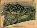 | 2,263 × 1,721 (1.3 MB) | Jengod | Uploaded a work by Juan Gallardo from Title: Map del Rancho de Sn. Pasqual [Calif.] : tiene poco mas o menos dos leguas .. Creator/Contributor: United States. District Court (California : Southern District). Land case. 248, Related Name Indexing Term Abstract: Shows drainage, roads, buildings, boundaries, adjoining ranchos, etc.Pen-and-ink and watercolor on tracing paper.From: U.S. District Court. California, Southern District. Land case 248 SD, page 180; land case map E-1289 (Bancroft Librar... |
File usage
- Diseño
- Ranchos of Los Angeles County
- Talk:Ranchos of Los Angeles County
- Wikipedia:Did you know/Statistics/Monthly DYK pageview leaders/2023/May
- Wikipedia:Main Page history/2023 May 10
- Wikipedia:Main Page history/2023 May 10b
- Wikipedia:Recent additions/2023/May
- Template:Did you know nominations/Ranchos of Los Angeles County
Global file usage
The following other wikis use this file:
- Usage on tum.wikipedia.org
- Usage on www.wikidata.org