
File:Dining Hall at Hartley's Factory Hartley Avenue Walton Liverpool Merseyside United Kingdom.jpg

Original file (4,000 × 3,000 pixels, file size: 6.28 MB, MIME type: image/jpeg)
| This is a file from the Wikimedia Commons. Information from its description page there is shown below. Commons is a freely licensed media file repository. You can help. |
Summary
| Description |
English: Dining hall at Hartley's Factory, Hartley Avenue, Walton, Liverpool, Merseyside, L9 7DB, United Kingdom.
The words 'Dining Hall' can be seen above the three large windows on the front of the building. The dining hall is Grade II listed, list entry number 1343619, see Historic England - Dining Hall at Hartley's Factory. (Archived from the original on 19 June 2015.) The dining hall is in the Hartley's Village Conservation Area, see item 12 on the map of Liverpool Conservation Areas, by Liverpool City Council. (Archived from the original on 19 June 2015.) The Hartley's Village Conservation Area is on the Historic England Heritage at Risk Regsiter, see here. (Archived from the original on 19 June 2015). The image was converted to jpg from the RAW file, using SILKYPIX Developer Studio. No other adjustments were made to the image. |
| Date | |
| Source | Own work |
| Author | PeterMLiverpoolLad5 |
| Camera location | | View this and other nearby images on: OpenStreetMap |
|---|
Licensing
- You are free:
- to share – to copy, distribute and transmit the work
- to remix – to adapt the work
- Under the following conditions:
- attribution – You must give appropriate credit, provide a link to the license, and indicate if changes were made. You may do so in any reasonable manner, but not in any way that suggests the licensor endorses you or your use.
- share alike – If you remix, transform, or build upon the material, you must distribute your contributions under the same or compatible license as the original.
File history
Click on a date/time to view the file as it appeared at that time.
| Date/Time | Thumbnail | Dimensions | User | Comment | |
|---|---|---|---|---|---|
| current | 20:46, 19 June 2015 | 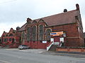 | 4,000 × 3,000 (6.28 MB) | PeterMLiverpoolLad5 | User created page with UploadWizard |