
File:Diagram of SWOT Data Collection.jpg

Size of this preview: 688 × 600 pixels. Other resolutions: 275 × 240 pixels | 551 × 480 pixels | 881 × 768 pixels | 1,174 × 1,024 pixels | 2,349 × 2,048 pixels | 3,428 × 2,989 pixels.
Original file (3,428 × 2,989 pixels, file size: 3.72 MB, MIME type: image/jpeg)
| This is a file from the Wikimedia Commons. Information from its description page there is shown below. Commons is a freely licensed media file repository. You can help. |
Summary
| Description |
English: diagram illustrating the swaths of data that SWOT will collect. The interferometer will produce two parallel tracks, with a Nadir track from a traditional altimeter in the gap between the swaths. The overall width of the swaths will be approximately 120 km.
Français : diagramme illustrant les fauchées sur lesquelles SWOT collectera des données. L'interféromètre produira deux traces parallèles, avec une trace au nadir d'un altimètre traditionnel dans l'espace entre les fauchées. La largeur totale des fauchées sera d'environ 120 km. |
| Date | |
| Source | https://swot.jpl.nasa.gov/gallery_more.htm?id=25 |
| Author | JPL/NASA |
Licensing
| This file is in the public domain in the United States because it was solely created by NASA. NASA copyright policy states that "NASA material is not protected by copyright unless noted". (See Template:PD-USGov, NASA copyright policy page or JPL Image Use Policy.) | ||
 |
Warnings:
|
File history
Click on a date/time to view the file as it appeared at that time.
| Date/Time | Thumbnail | Dimensions | User | Comment | |
|---|---|---|---|---|---|
| current | 14:22, 6 June 2019 | 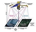 | 3,428 × 2,989 (3.72 MB) | CatherinElsa | User created page with UploadWizard |
File usage
The following pages on the English Wikipedia use this file (pages on other projects are not listed):
Global file usage
The following other wikis use this file:
- Usage on fr.wikipedia.org