
File:Demchok-sector-map.jpg

Size of this preview: 490 × 599 pixels. Other resolutions: 196 × 240 pixels | 392 × 480 pixels | 762 × 932 pixels.
Original file (762 × 932 pixels, file size: 95 KB, MIME type: image/jpeg)
| This is a file from the Wikimedia Commons. Information from its description page there is shown below. Commons is a freely licensed media file repository. You can help. |
Summary
| Description |
English: The Line of Actual Control in the Demchok sector shown in bold, with China's claim line to the left and India's claim line shown to the right. |
| Date | |
| Source | https://www.openstreetmap.org/#map=10/32.9031/79.3776 |
| Author | OpenStreetMap, annotated by User:Kautilya3 |
Licensing
| This work contains information from OpenStreetMap, which is made available under the Open Database License (ODbL).
The ODbL does not require any particular license for maps produced from ODbL data. Prior to 1 August 2020, map tiles produced by the OpenStreetMap Foundation were licensed under the CC-BY-SA-2.0 license. Maps produced by other people may be subject to other licences. |
This file is licensed under the Creative Commons Attribution-Share Alike 2.0 Generic license.
- You are free:
- to share – to copy, distribute and transmit the work
- to remix – to adapt the work
- Under the following conditions:
- attribution – You must give appropriate credit, provide a link to the license, and indicate if changes were made. You may do so in any reasonable manner, but not in any way that suggests the licensor endorses you or your use.
- share alike – If you remix, transform, or build upon the material, you must distribute your contributions under the same or compatible license as the original.
This file, which was originally posted to
https://www.opentopomap.org/#map=11/32.7685/79.5348, was reviewed on 23 December 2020 by reviewer Nat, who confirmed that it was available there under the stated license on that date.
|
File history
Click on a date/time to view the file as it appeared at that time.
| Date/Time | Thumbnail | Dimensions | User | Comment | |
|---|---|---|---|---|---|
| current | 22:20, 31 May 2021 | 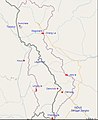 | 762 × 932 (95 KB) | Kautilya3 | Labelled additional points |
| 19:29, 2 November 2020 |  | 762 × 932 (93 KB) | Kautilya3 | Uploaded a work by OpenStreetMap, annotated by User:Kautilya3 from https://www.opentopomap.org/#map=11/32.7685/79.5348 with UploadWizard |
File usage
The following pages on the English Wikipedia use this file (pages on other projects are not listed):