
File:Delaware-Greene-Ulster tri-county point on Halcott Mountain south ridge, NY.jpg

Size of this preview: 800 × 522 pixels. Other resolutions: 320 × 209 pixels | 640 × 417 pixels | 1,024 × 668 pixels | 1,280 × 835 pixels | 2,560 × 1,670 pixels | 4,968 × 3,240 pixels.
Original file (4,968 × 3,240 pixels, file size: 18.25 MB, MIME type: image/jpeg)
| This is a file from the Wikimedia Commons. Information from its description page there is shown below. Commons is a freely licensed media file repository. You can help. |
| Description |
English: Rock cairn marking (inadvertently, anyway) the tripoint of New York's Delaware, Greene and Ulster counties along the south ridge of Halcott Mountain in the Catskills.
The lower left is in Delaware County's town of Middletown. The lower right is in Shandaken, in Ulster County, and the area at the top of the image is in the Greene County town of :Lexington. Yellow splotch of paint on top indicates the intended purpose, to mark the corner of state land in Ulster County. It also marks a corner of the Catskill Park Blue Line, which at this point follows the Delaware County line |
||
| Date | |||
| Source | Own work | ||
| Author | Daniel Case | ||
| Permission (Reusing this file) |
I, the copyright holder of this work, hereby publish it under the following licenses:
This file is licensed under the Creative Commons Attribution-Share Alike 3.0 Unported license.
You may select the license of your choice. |

| Camera location | | View this and other nearby images on: OpenStreetMap |
|---|
The geographical information in this file was retrospectively estimated.
The location may therefore be somewhat imprecise. Verifying and refining these coordinates is strongly encouraged. |
File history
Click on a date/time to view the file as it appeared at that time.
| Date/Time | Thumbnail | Dimensions | User | Comment | |
|---|---|---|---|---|---|
| current | 04:27, 1 September 2016 | 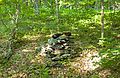 | 4,968 × 3,240 (18.25 MB) | Daniel Case | {{Information |Description ={{en|1=Rock cairn marking (inadvertently, anyway) the tripoint of Delaware, Greene and Ulster counties along the s... |
File usage
The following pages on the English Wikipedia use this file (pages on other projects are not listed):