
File:Decolonization - World Today en.svg

Original file (SVG file, nominally 1,438 × 832 pixels, file size: 3.76 MB)
| This is a file from the Wikimedia Commons. Information from its description page there is shown below. Commons is a freely licensed media file repository. You can help. |
| Description |
English: Derivative work based on UN Map No. 4136 Rev. 8, updated in May 2010 by UN Department of Field Support, Cartographic Section
Taken from the UN's decolonization website. Only modification was a conversion to SVG and per UN license, removal of reference information from the map. Map was used to show the progress of the UN's decolonization efforts. In fulfillment of a Wikipedia Graphics Lab: Map Workshop request by User:Gryffindor, referencing a photo taken by User:Deror_avi at the UN building.English: Member States of the UN English: Non-Self-Governing Territories English: Non-Member States of the UN English: Observer Non-Member States of the UN |
|||
| Date | Unknown date, last update in May 2010 | |||
| Source | The United Nations Cartographic map | |||
| Author | United Nations Department of Field Support, Cartographic Section | |||
| Permission (Reusing this file) |
|

File history
Click on a date/time to view the file as it appeared at that time.
| Date/Time | Thumbnail | Dimensions | User | Comment | |
|---|---|---|---|---|---|
| current | 21:28, 10 October 2020 |  | 1,438 × 832 (3.76 MB) | Bidgee | Reverted to version as of 04:50, 7 September 2010 (UTC) if you dispute it, upload under a new file per COM:OVERWRITE |
| 22:58, 4 October 2020 |  | 1,438 × 832 (591 KB) | Бмхүн | Reverted to version as of 15:08, 30 October 2016 (UTC) The UN official map isnot include Taiwan or Kosovo,such as Somaliland and other selfclaimed indentpent states | |
| 22:09, 9 August 2020 |  | 1,438 × 832 (848 KB) | Glide08 | Reverted to version as of 13:59, 11 November 2019 (UTC) | |
| 02:14, 4 May 2020 |  | 1,438 × 832 (591 KB) | Anchuhu | Reverted to version as of 15:08, 30 October 2016 (UTC) | |
| 13:59, 11 November 2019 |  | 1,438 × 832 (848 KB) | Glide08 | If this map was modified to include South Sudan I see no good reason why it shouldn't include Taiwan and Kosovo as well. Also updated FYROM → North Macedonia. | |
| 15:08, 30 October 2016 |  | 1,438 × 832 (591 KB) | BurritoBazooka | Unsure why size increased so much. Retype text at bottom (was originally individual letters), used github.com/scour-project/scour (with --keep-editor-data). | |
| 10:49, 30 October 2016 |  | 1,438 × 832 (1.07 MB) | BurritoBazooka | adding South Sudan and its two territorial disputes with Sudan | |
| 22:14, 21 May 2012 |  | 1,438 × 832 (716 KB) | 25or6to4 | switched to acceptable font, should fix text placement issues | |
| 22:14, 7 September 2010 |  | 1,438 × 832 (427 KB) | Gringer | whoops, wrong map | |
| 22:04, 7 September 2010 | 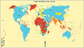 | 1,438 × 832 (497 KB) | Gringer | trying with Arial as font-family |
File usage
Global file usage
The following other wikis use this file:
- Usage on bg.wikipedia.org
- Usage on bn.wikipedia.org
- Usage on ca.wikipedia.org
- Usage on de.wikipedia.org
- Usage on es.wikipedia.org
- Usage on fa.wikipedia.org
- Usage on fi.wikipedia.org
- Usage on fr.wikipedia.org
- Usage on id.wikipedia.org
- Usage on ko.wikipedia.org
- Usage on ms.wikipedia.org
- Usage on ne.wikipedia.org
- Usage on nl.wikipedia.org
- Usage on no.wikipedia.org
- Usage on pl.wikiquote.org
- Usage on so.wikipedia.org
- Usage on sv.wikipedia.org
- Usage on ta.wikipedia.org
- Usage on uz.wikipedia.org
- Usage on vi.wikipedia.org
- Usage on zh.wikipedia.org