
File:Cyark Banteay plan.jpg

No higher resolution available.
Cyark_Banteay_plan.jpg (481 × 350 pixels, file size: 13 KB, MIME type: image/jpeg)
| This is a file from the Wikimedia Commons. Information from its description page there is shown below. Commons is a freely licensed media file repository. You can help. |
Summary
| Description | Plan of Banteay Kdei, a temple at Angkor, Cambodia, cut from a laser Scan. It is located southeast of Ta Prohm and east of Angkor Thom. Built in the late 12th to early 13th centuriesCE during the reign of Jayavarman VII, it is a Buddhist temple in the Bayon style, similar in plan to Ta Prohm and Preah Khan, but less complex and smaller. Its structures are contained within two successive enclosure walls, and consist of two concentric galleries from which emerge towers, preceded to the east by a cloister. This monastic complex is currently dilapidated due to faulty construction and poor quality sandstone. Banteay Kdei has been occupied by monks at various intervals over the centuries, but the inscription stone has never been discovered so it is unknown to whom the temple is dedicated. |
| Source | CyArk |
| Author | CyArk |
| Permission (Reusing this file) |
Creative Commons image, freely usable for any purpose with site attribution (www.cyark.org) |
Licensing
This file is licensed under the Creative Commons Attribution-Share Alike 3.0 Unported license.
- You are free:
- to share – to copy, distribute and transmit the work
- to remix – to adapt the work
- Under the following conditions:
- attribution – You must give appropriate credit, provide a link to the license, and indicate if changes were made. You may do so in any reasonable manner, but not in any way that suggests the licensor endorses you or your use.
- share alike – If you remix, transform, or build upon the material, you must distribute your contributions under the same or compatible license as the original.
File history
Click on a date/time to view the file as it appeared at that time.
| Date/Time | Thumbnail | Dimensions | User | Comment | |
|---|---|---|---|---|---|
| current | 23:23, 9 January 2008 | 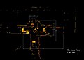 | 481 × 350 (13 KB) | DuendeThumb | {{Information |Description= Plan of Banteay Kdei, a temple at Angkor, Cambodia, cut from a laser Scan. It is located southeast of Ta Prohm and east of Angkor Thom. Built in the late 12th to early [[13th cent |
File usage
The following pages on the English Wikipedia use this file (pages on other projects are not listed):
Global file usage
The following other wikis use this file:
- Usage on id.wikipedia.org
- Usage on it.wikipedia.org
- Usage on ja.wikipedia.org
- Usage on no.wikipedia.org
- Usage on uk.wikipedia.org