
File:Curtiss Hotel (aka Harlow C. Curtiss Building, King & Eisele Building, Hoelscher Building) - Buffalo, New York - 20211104.jpg

Size of this preview: 768 × 600 pixels. Other resolutions: 307 × 240 pixels | 615 × 480 pixels | 983 × 768 pixels | 1,280 × 1,000 pixels | 2,560 × 2,000 pixels | 3,522 × 2,751 pixels.
Original file (3,522 × 2,751 pixels, file size: 3.29 MB, MIME type: image/jpeg)
| This is a file from the Wikimedia Commons. Information from its description page there is shown below. Commons is a freely licensed media file repository. You can help. |
Summary
| Description |
English: The Curtiss Hotel, 210 Franklin Street at West Huron Street, Buffalo, New York, November 2021. Built in 1913 as a speculative venture by attorney-turned-real estate investor Harlow C. Curtiss, the aesthetic of this exquisite edifice - the work of local architect Paul F. Mann - melds Art Nouveau decorative principles with the basic forms (and advances in structural technology) innovated by the Chicago School, a stylistic marriage that was very popular in commercial buildings of the period (the Prudential Building on Church Street is another local example). As expected, ornamentation is Classically-derived and quite florid: urns in relief are stacked in columns between the triple sets of windows; geometric designs in circle and diamond shapes adorn the spandrel panels; the frieze that separates the fifth floor from the sixth is lined with scrolling acanthus leaves; more urns, these festooned with garlands, are interspersed between the upper-story windows. Home to a multiplicity of retail, office and government tenants that over the years have included the Kittinger Furniture Company, King & Eisele Jewelers, Catholic Charities (who leased the entire fourth floor in the 1960s), and the Workmen's Compensation Board, the building was a successful investment for Curtiss, but he only owned it for several years; it served a similar function under subsequent owners. By 2009, when the late real estate developer Mark Croce purchased it with plans for a luxury hotel, the building had been vacant and boarded up for some time. The Curtiss Hotel opened in 2017. |
| Date | |
| Source | Own work |
| Author | Andre Carrotflower |
| Camera location | | View this and other nearby images on: OpenStreetMap |
|---|
Licensing
I, the copyright holder of this work, hereby publish it under the following license:
This file is licensed under the Creative Commons Attribution-Share Alike 4.0 International license.
- You are free:
- to share – to copy, distribute and transmit the work
- to remix – to adapt the work
- Under the following conditions:
- attribution – You must give appropriate credit, provide a link to the license, and indicate if changes were made. You may do so in any reasonable manner, but not in any way that suggests the licensor endorses you or your use.
- share alike – If you remix, transform, or build upon the material, you must distribute your contributions under the same or compatible license as the original.
File history
Click on a date/time to view the file as it appeared at that time.
| Date/Time | Thumbnail | Dimensions | User | Comment | |
|---|---|---|---|---|---|
| current | 03:46, 20 November 2021 | 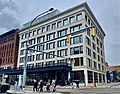 | 3,522 × 2,751 (3.29 MB) | Andre Carrotflower | Uploaded own work with UploadWizard |
File usage
The following pages on the English Wikipedia use this file (pages on other projects are not listed):
Global file usage
The following other wikis use this file:
- Usage on it.wikivoyage.org
- Usage on www.wikidata.org