
File:Cornwall UK location map placenames.png

Size of this preview: 800 × 588 pixels. Other resolutions: 320 × 235 pixels | 640 × 471 pixels | 1,024 × 753 pixels | 1,280 × 941 pixels | 1,425 × 1,048 pixels.
Original file (1,425 × 1,048 pixels, file size: 345 KB, MIME type: image/png)
| This is a file from the Wikimedia Commons. Information from its description page there is shown below. Commons is a freely licensed media file repository. You can help. |
Summary
| Description |
Map of Cornwall, UK (excluding the Isles of Scilly) with the following information shown:
Equirectangular map projection on WGS 84 datum, with N/S stretched 150% Geographic limits:
|
| Date | |
| Source | w:File:Cornwall UK mainland location map.svg – Base map |
| Author | Originally Nilfanion, created using Ordnance Survey data. Locations added by SchroCat |
| Permission (Reusing this file) |
This file is licensed under the Creative Commons Attribution-Share Alike 3.0 Unported license. Attribution: Contains Ordnance Survey data © Crown copyright and database right
|
| Other versions | w:File:Cornwall UK mainland location map.svg – Base map |
Licensing
Original upload log
The original description page was here. All following user names refer to en.wikipedia.
| Date/Time | Dimensions | User | Comment |
|---|---|---|---|
| 2016-09-29 16:35:52 | 1425 × 1048 | Brianboulton | {{Information |Description=Map of [[w:Cornwall|Cornwall]], UK (excluding the Isles of Scilly) with the following information shown: *Administrative borders *Coastline, lakes and rivers *Roads and railways *Urban areas Equirectangular map projection on... |
File history
Click on a date/time to view the file as it appeared at that time.
| Date/Time | Thumbnail | Dimensions | User | Comment | |
|---|---|---|---|---|---|
| current | 02:57, 30 January 2018 | 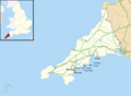 | 1,425 × 1,048 (345 KB) | Lingzhi | Added Portloe, Nare Head & Dodman Point |
| 10:31, 3 April 2017 | 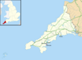 | 1,425 × 1,048 (334 KB) | Feminist | Transferred from en.wikipedia (MTC!) |
File usage
The following pages on the English Wikipedia use this file (pages on other projects are not listed):