
File:Copy of Elcor Townsite Plat 2.jpg
Original file (800 × 996 pixels, file size: 118 KB, MIME type: image/jpeg)
| This non-free media file has been set up with as small a version as possible, to comply with Wikipedia's non-free content policy and United States copyright law. The current resolution has been manually selected to achieve as small an image as possible without destroying the image content. According to Wikipedia's policy for non-free content, the amount of non-free work should be as little as possible. In particular, non-free media on Wikipedia should not be usable as substitutes for the original work. |
Summary[edit]
| Description |
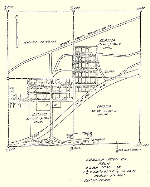
Elcor town site plat map, c. 1921-1926. From the Frank A. Wildes, Superintendent of Mines Subject Files, 1921-1933, Minnesota Auditor Land Department. |
|---|---|
| Source |
State Archives of the Minnesota Historical Society. Derived from a photocopy and subsequent digital capture of the plat map. It cannot be ruled out with 100% certainty that the plat map may be pre-1923. It may be as early as 1921 since the name Elcor was adopted in 1920 or it may be as late as 1926 since the No. 5 shaft of the Elba mine is still depicted (the Elba mine was closed in 1926). Claimed as fair-use regardless. |
| Article | |
| Portion used |
Only the original plat map of the Superintendent of Mines Subject Files was used. |
| Low resolution? |
Yes, the image was photocopied and then scanned for use in the article with a loss of resolution. |
| Purpose of use |
The image serves as the primary means of visual identification for the plat and layout of town site, depicting the streets, lots, the Duluth and Iron Range Railroad right-of-way (the Duluth, Missabe and Iron Range right-of-way in 1938), buildings, mine shafts and highways as described in the article Elcor, Minnesota. |
| Replaceable? |
Even if the image is pre-1923 and in the public domain, no other plat maps of Elcor can be found or are known to exist, so the image cannot be replaced by a free image. |
| Other information |
Use of the image meets Wikipedia content requirements and significantly improves the article. DrGregMN (talk) 14:49, 11 December 2017 (UTC) |
| Fair useFair use of copyrighted material in the context of Elcor, Minnesota//en.wikipedia.org/wiki/File:Copy_of_Elcor_Townsite_Plat_2.jpgtrue | |
Licensing[edit]
 | This work is copyrighted (or assumed to be copyrighted) and unlicensed. It does not fall into one of the blanket acceptable non-free content categories listed at Wikipedia:Non-free content § Images or Wikipedia:Non-free content § Audio clips, and it is not covered by a more specific non-free content license listed at Category:Wikipedia non-free file copyright templates. However, it is believed that the use of this work:
qualifies as fair use under United States copyright law. Any other uses of this image, on Wikipedia or elsewhere, may be copyright infringement. See Wikipedia:Non-free content and Wikipedia:Copyrights. | ||
| |||
File history
Click on a date/time to view the file as it appeared at that time.
| Date/Time | Thumbnail | Dimensions | User | Comment | |
|---|---|---|---|---|---|
| current | 22:56, 11 December 2017 |  | 800 × 996 (118 KB) | Ronhjones (talk | contribs) | Reverted to version as of 14:40, 11 December 2017 (UTC) - not suitable for guideline size |
| 22:55, 11 December 2017 | No thumbnail | 283 × 352 (18 KB) | DatBot (talk | contribs) | Reduce size of non-free image (BOT - disable) | |
| 14:40, 11 December 2017 | No thumbnail | 800 × 996 (118 KB) | Vanished User G4152887770657188005249Z1071175500262271186025 (talk | contribs) | {{Non-free use rationale |Article = Elcor, Minnesota |Description = Elcor town site plat map, c. 1291-1926. From the Frank A. Wildes, Superintendent of Mines Subject Files, 1921-1933, Minnesota Auditor Land Department. |Source... |
You cannot overwrite this file.