
File:Chequamegon1755.jpg

No higher resolution available.
Chequamegon1755.jpg (424 × 332 pixels, file size: 56 KB, MIME type: image/jpeg)
| This is a file from the Wikimedia Commons. Information from its description page there is shown below. Commons is a freely licensed media file repository. You can help. |
Summary
| Description |
English: Snippet of French Map showing Chequamegon Bay on Lake Superior with inset of larger map.
Français : Partie occidentale de la Nouvelle France ou du Canada par Mr. Bellin, ingénieur du roy de la marine pour servir à l'intelligence des affaires de l'etat present en Amerique, communiquée au public par les Héritiers de Homan. |
| Date | |
| Source | Library of Congress Map Collection |
| Author | Bellin |
| Permission (Reusing this file) |
public domain (old) |
Licensing
|
This work is in the public domain in its country of origin and other countries and areas where the copyright term is the author's life plus 100 years or fewer. | |
| This file has been identified as being free of known restrictions under copyright law, including all related and neighboring rights. | |
File history
Click on a date/time to view the file as it appeared at that time.
| Date/Time | Thumbnail | Dimensions | User | Comment | |
|---|---|---|---|---|---|
| current | 21:15, 18 February 2008 | 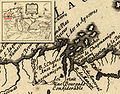 | 424 × 332 (56 KB) | Leo1410 | {{Information |Description=Snippet of French Map showing Chequamegon Bay on Lake Superior with inset of larger map. Partie occidentale de la Nouvelle France ou du Canada par Mr. Bellin, ingénieur du roy de la marine pour servir à l'intelligence des aff |
File usage
The following pages on the English Wikipedia use this file (pages on other projects are not listed):
Global file usage
The following other wikis use this file:
- Usage on fr.wikipedia.org