
File:Central African Republic relief location map.jpg

Size of this preview: 800 × 553 pixels. Other resolutions: 320 × 221 pixels | 640 × 442 pixels | 1,024 × 707 pixels | 1,280 × 884 pixels | 1,785 × 1,233 pixels.
Original file (1,785 × 1,233 pixels, file size: 1.1 MB, MIME type: image/jpeg)
| This is a file from the Wikimedia Commons. Information from its description page there is shown below. Commons is a freely licensed media file repository. You can help. |
| Description |
Deutsch: Physische Positionskarte der Zentralafrikanischen Republik
Quadratische Plattkarte, N-S-Streckung 101 %. Geographische Begrenzung der Karte:
English: Physical location map of the Central African Republic
Equirectangular projection, N/S stretching 101 %. Geographic limits of the map:
|
| Date | |
| Source | Own work, map data from administrative map by NNW, SRMT30-data for the relief |
| Author | Carport |
| Permission (Reusing this file) |
This file is licensed under the Creative Commons Attribution-Share Alike 3.0 Unported license.
|
| Other versions |
|

File history
Click on a date/time to view the file as it appeared at that time.
| Date/Time | Thumbnail | Dimensions | User | Comment | |
|---|---|---|---|---|---|
| current | 14:06, 29 September 2011 |  | 1,785 × 1,233 (1.1 MB) | NordNordWest | correct file |
| 14:05, 29 September 2011 | 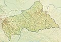 | 1,785 × 1,233 (343 KB) | NordNordWest | + South Sudan | |
| 11:16, 7 March 2010 |  | 1,785 × 1,233 (1.07 MB) | Carport | {{Information |Description={{de|Physische Positionskarte der Zentralafrikanischen Republik}} Quadratische Plattkarte, N-S-Streckung 101 %. Geographische Begrenzung der Karte: * N: 11.3° N * S: 2.0° N * W: 14.1° O * |
File usage
The following pages on the English Wikipedia use this file (pages on other projects are not listed):
- 2022 Gadzi clashes
- Bamingui-Bangoran National Park and Biosphere Reserve
- Bangui
- Chinko River
- Dzanga-Ndoki National Park
- Dzanga-Sangha Special Reserve
- Kotto River
- Lobaye River
- Léon Hanolet
- Manovo-Gounda St. Floris National Park
- Mbari River
- Mont Abourasséin
- Mont Ngaoui
- Nana Barya Faunal Reserve
- Ndji River
- Phrynobatrachus elberti
- Phrynobatrachus nanus
- Phrynobatrachus pygmaeus
- Théodore Nilis
- Vassako Bolo Strict Nature Reserve
- Zemongo Faunal Reserve
- Module:Location map/data/Central African Republic
- Module:Location map/data/Central African Republic/doc
Global file usage
The following other wikis use this file:
- Usage on ar.wikipedia.org
- Usage on ast.wikipedia.org
- Usage on az.wikipedia.org
- Usage on be.wikipedia.org
- Usage on bg.wikipedia.org
- Usage on bn.wikipedia.org
- Usage on bs.wikipedia.org
- Usage on ceb.wikipedia.org
- Usage on ce.wikipedia.org
- Usage on ckb.wikipedia.org
- Usage on cs.wikipedia.org
- Usage on da.wikipedia.org
- Usage on de.wikipedia.org
- Zentralafrikanische Republik
- Zentralafrikanisches Kaiserreich
- Nationalpark Manovo-Gounda Saint Floris
- Bongo-Massiv
- Vorlage:Positionskarte Zentralafrikanische Republik
- Wikipedia:Kartenwerkstatt/Positionskarten/Afrika
- Benutzer:Carport/Galerie
- Boali-Talsperre
- Wikipedia:Kartenwerkstatt/Archiv/2010-03
- Bomboro-See
- Mamoun-See
- Boukoko-See
- Njenge-See
- Manuela-See
- Boalifälle
- Mont Ngaoui
- Yadé-Massiv
- Mont Toussoro
- Goulé
- Koun Nzoro
- Pana (Zentralafrikanische Republik)
- Djebel Abu Rasein
- Mont Dandji
- Mont Patara
- Mont Mali
- Mont Bali
- Ndim (Berg)
View more global usage of this file.