
File:Carte politique de l'Indo-Chine (...)Deloncle François btv1b53025089w.jpg

Size of this preview: 396 × 599 pixels. Other resolutions: 159 × 240 pixels | 317 × 480 pixels | 508 × 768 pixels | 1,024 × 1,548 pixels.
Original file (1,024 × 1,548 pixels, file size: 413 KB, MIME type: image/jpeg)
| This is a file from the Wikimedia Commons. Information from its description page there is shown below. Commons is a freely licensed media file repository. You can help. |
Summary
| Description |
English: Political map of Indochina, published by F. Appel, Parrot et Cie (Paris) 41 x 64 cm |
| Date | |
| Source | http://gallica.bnf.fr/ark:/12148/btv1b53025089w/f1.item |
| Author | François Deloncle (14 August 1856 – 21 October 1922) |
Licensing
|
This work is in the public domain in its country of origin and other countries and areas where the copyright term is the author's life plus 70 years or fewer. This work is in the public domain in the United States because it was published (or registered with the U.S. Copyright Office) before January 1, 1929. | |
| This file has been identified as being free of known restrictions under copyright law, including all related and neighboring rights. | |
File history
Click on a date/time to view the file as it appeared at that time.
| Date/Time | Thumbnail | Dimensions | User | Comment | |
|---|---|---|---|---|---|
| current | 11:33, 27 April 2018 | 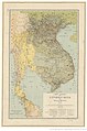 | 1,024 × 1,548 (413 KB) | Aymatth2 | User created page with UploadWizard |
File usage
No pages on the English Wikipedia use this file (pages on other projects are not listed).
Global file usage
The following other wikis use this file:
- Usage on fr.wikipedia.org
- Usage on ja.wikipedia.org
- Usage on km.wikipedia.org