
File:Carrington moss map 1937.jpg

Size of this preview: 800 × 455 pixels. Other resolutions: 320 × 182 pixels | 640 × 364 pixels | 1,097 × 624 pixels.
Original file (1,097 × 624 pixels, file size: 194 KB, MIME type: image/jpeg)
| This is a file from the Wikimedia Commons. Information from its description page there is shown below. Commons is a freely licensed media file repository. You can help. |
Summary
| Description |
English: The center map is Bolton and Manchester, England and Wales Popular (4th) edition. Published in 1937. Based on 1924 mapping. Donated by Joyce Whitchurch.
Green boundary taken from page 17 of
|
| Date | |
| Source | http://www.ponies.me.uk/maps/osmap.html?z=11&x=-2.3888397216796875&y=53.42180918342967 |
| Author | Ordnance Survey |
Licensing
This work created by the United Kingdom Government is in the public domain.
This is because it is one of the following:
HMSO has declared that the expiry of Crown Copyrights applies worldwide (ref: HMSO Email Reply)
|
 |
File history
Click on a date/time to view the file as it appeared at that time.
| Date/Time | Thumbnail | Dimensions | User | Comment | |
|---|---|---|---|---|---|
| current | 21:43, 17 May 2009 |  | 1,097 × 624 (194 KB) | Parrot of Doom | Align boundary with features and reduce strength of green |
| 20:15, 11 May 2009 | 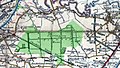 | 1,097 × 624 (226 KB) | Parrot of Doom | Overlaid the Carrington Moss Estate in green | |
| 21:05, 5 May 2009 |  | 1,097 × 624 (197 KB) | Parrot of Doom | {{Information |Description={{en|1=The center map is Bolton and Manchester, England and Wales Popular (4th) edition. Published in 1937. Based on 1924 mapping. Donated by Joyce Whitchurch. Cropped to show Carrington Moss.}} |Source=http://www.ponies.me.uk/ |
File usage
The following pages on the English Wikipedia use this file (pages on other projects are not listed):
Global file usage
The following other wikis use this file:
- Usage on fr.wikipedia.org