
File:CH Viamala Gorge descent.jpg
Size of this preview: 800 × 287 pixels. Other resolutions: 320 × 115 pixels | 640 × 230 pixels | 1,024 × 368 pixels | 1,280 × 459 pixels | 5,572 × 2,000 pixels.
Original file (5,572 × 2,000 pixels, file size: 4.61 MB, MIME type: image/jpeg)
| This is a file from the Wikimedia Commons. Information from its description page there is shown below. Commons is a freely licensed media file repository. You can help. |
Summary
| Camera location | | View this and other nearby images on: OpenStreetMap |
|---|
| Description |
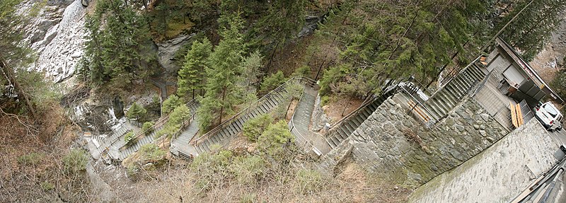
English: Descent into the Via mala (“evil road”), a gorge near Thusis, Switzerland.
Français : La descente dans la Via mala («Le mauvais chemin»), une gorge près de Thusis, en Suisse.
Deutsch: Abstieg in die Via mala („der schlechte Weg“), eine Schlucht bei Thusis in der Schweiz. |
| Date | |
| Source | Own work |
| Author | Daniel Schwen |
Licensing
I, the copyright holder of this work, hereby publish it under the following license:
This file is licensed under the Creative Commons Attribution-Share Alike 2.5 Generic license.
- You are free:
- to share – to copy, distribute and transmit the work
- to remix – to adapt the work
- Under the following conditions:
- attribution – You must give appropriate credit, provide a link to the license, and indicate if changes were made. You may do so in any reasonable manner, but not in any way that suggests the licensor endorses you or your use.
- share alike – If you remix, transform, or build upon the material, you must distribute your contributions under the same or compatible license as the original.
This image has been assessed using the Quality image guidelines and is considered a Quality image.
|
File history
Click on a date/time to view the file as it appeared at that time.
| Date/Time | Thumbnail | Dimensions | User | Comment | |
|---|---|---|---|---|---|
| current | 18:21, 27 March 2007 | 5,572 × 2,000 (4.61 MB) | Dschwen | {{Information |Description=Descent into the Viamala gorge near Thusis, Switzerland. |Source=Own work |Date=March 23rd, 2007 |Author=Daniel Schwen |Permission=See license |other_versions= }} |
File usage
The following pages on the English Wikipedia use this file (pages on other projects are not listed):
Global file usage
The following other wikis use this file:
- Usage on azb.wikipedia.org
- Usage on cs.wikipedia.org
- Usage on de.wikipedia.org
- Usage on fr.wikipedia.org
- Usage on rm.wikipedia.org
- Usage on ru.wikisource.org
- Usage on sl.wikipedia.org