
File:Côte d'Ivoire topographic map-fr.svg

Size of this PNG preview of this SVG file: 586 × 599 pixels. Other resolutions: 235 × 240 pixels | 469 × 480 pixels | 751 × 768 pixels | 1,001 × 1,024 pixels | 2,003 × 2,048 pixels | 843 × 862 pixels.
Original file (SVG file, nominally 843 × 862 pixels, file size: 1.67 MB)
| This is a file from the Wikimedia Commons. Information from its description page there is shown below. Commons is a freely licensed media file repository. You can help. |
| Description |
Français : Carte physique de la Côte d'Ivoire. Note : le fond de carte (relief + rivières) est un bitmap (SRTM30 v.2/domaine publique) embarqué dans le svg à l'aide d'Inkscape.
English: Map of Côte d'Ivoire.
Equirectangular projection, WGS84 datum
|
| Date | |
| Source |
Own work by uploader *Topography : NASA Shuttle Radar Topography Mission (SRTM30 v.2) (public domain) ; *Shoreline and additional data : Demis World Map Data + World data bank II. *Bathymétrie (océan) : Demis World Map Data, vectorisées by Inkscape *Other : Inkscape ; The Gimp |
| Author | Bourrichon - fr:Bourrichon |
| Other versions |
|


Licensing
I, the copyright holder of this work, hereby publish it under the following licenses:

|
Permission is granted to copy, distribute and/or modify this document under the terms of the GNU Free Documentation License, Version 1.2 or any later version published by the Free Software Foundation; with no Invariant Sections, no Front-Cover Texts, and no Back-Cover Texts. A copy of the license is included in the section entitled GNU Free Documentation License. |
This file is licensed under the Creative Commons Attribution-Share Alike 4.0 International, 3.0 Unported, 2.5 Generic, 2.0 Generic and 1.0 Generic license.
- You are free:
- to share – to copy, distribute and transmit the work
- to remix – to adapt the work
- Under the following conditions:
- attribution – You must give appropriate credit, provide a link to the license, and indicate if changes were made. You may do so in any reasonable manner, but not in any way that suggests the licensor endorses you or your use.
- share alike – If you remix, transform, or build upon the material, you must distribute your contributions under the same or compatible license as the original.
You may select the license of your choice.
File history
Click on a date/time to view the file as it appeared at that time.
| Date/Time | Thumbnail | Dimensions | User | Comment | |
|---|---|---|---|---|---|
| current | 15:20, 20 February 2009 | 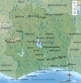 | 843 × 862 (1.67 MB) | Bourrichon | . |
| 14:44, 20 February 2009 |  | 843 × 862 (1.67 MB) | Bourrichon | + lacs/lagunes | |
| 14:23, 20 February 2009 |  | 843 × 862 (1.62 MB) | Bourrichon | {{Information |Description={{fr|Carte physique de la Côte d'Ivoire. Note : le fond de carte (relief + rivières) est un bitmap (SRTM30 v.2/domaine publique) embarqué dans le svg à l'aide d'Inkscape.}} {{en|Map of [[:en:Côte d'Iv |
File usage
The following pages on the English Wikipedia use this file (pages on other projects are not listed):
Global file usage
The following other wikis use this file:
- Usage on ca.wikipedia.org
- Usage on ckb.wikipedia.org
- Usage on fa.wikipedia.org
- Usage on fr.wikipedia.org
- Usage on hr.wiktionary.org
- Usage on id.wikipedia.org
- Usage on mdf.wikipedia.org
- Usage on mzn.wikipedia.org
- Usage on nl.wikipedia.org
- Usage on uk.wikipedia.org
- Usage on www.wikidata.org