
File:Bury Council Wards Numbered.png
Size of this preview: 386 × 600 pixels. Other resolutions: 154 × 240 pixels | 309 × 480 pixels | 840 × 1,305 pixels.
Original file (840 × 1,305 pixels, file size: 136 KB, MIME type: image/png)
| This is a file from the Wikimedia Commons. Information from its description page there is shown below. Commons is a freely licensed media file repository. You can help. |
| I, the copyright holder of this work, release this work into the public domain. This applies worldwide. In some countries this may not be legally possible; if so: I grant anyone the right to use this work for any purpose, without any conditions, unless such conditions are required by law. |
Summary
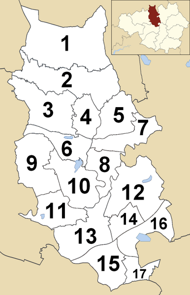
Map of Bury, Greater Manchester, UK with electoral wards numbered
File history
Click on a date/time to view the file as it appeared at that time.
| Date/Time | Thumbnail | Dimensions | User | Comment | |
|---|---|---|---|---|---|
| current | 04:07, 21 September 2019 |  | 840 × 1,305 (136 KB) | The Vintage Feminist | Added the numbers. |
| 16:19, 16 September 2019 |  | 840 × 1,305 (147 KB) | The Vintage Feminist | Map of Bury, Greater Manchester, UK with electoral wards numbered. Category:Maps of the Metropolitan Borough of Bury Category:Ordnance Survey Boundary Line maps Category:Wards of the United Kingdom Category:Maps numbering |
File usage
The following pages on the English Wikipedia use this file (pages on other projects are not listed):