
File:Burundi Topography.png
Size of this preview: 587 × 599 pixels. Other resolutions: 235 × 240 pixels | 470 × 480 pixels | 752 × 768 pixels | 1,003 × 1,024 pixels | 1,628 × 1,662 pixels.
Original file (1,628 × 1,662 pixels, file size: 3.78 MB, MIME type: image/png)
| This is a file from the Wikimedia Commons. Information from its description page there is shown below. Commons is a freely licensed media file repository. You can help. |
Summary
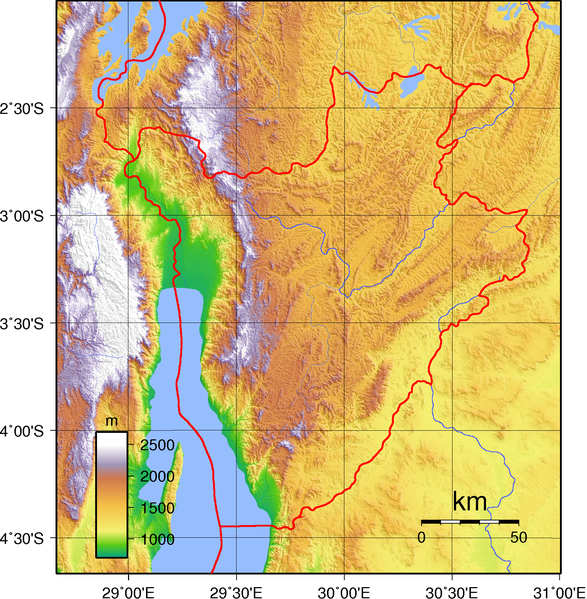
| Description | Topographic Map of Burundi. Created with GMT from public domain SRTM data. |
| Date | |
| Source | Own work |
| Author | Sadalmelik |
Licensing
| This work has been released into the public domain by its author, I, Sadalmelik. This applies worldwide. In some countries this may not be legally possible; if so: I, Sadalmelik grants anyone the right to use this work for any purpose, without any conditions, unless such conditions are required by law. |
File history
Click on a date/time to view the file as it appeared at that time.
| Date/Time | Thumbnail | Dimensions | User | Comment | |
|---|---|---|---|---|---|
| current | 19:14, 29 June 2007 |  | 1,628 × 1,662 (3.78 MB) | Sadalmelik | Better data/colours |
| 12:23, 17 June 2007 |  | 1,625 × 1,662 (3.8 MB) | Sadalmelik | {{Information |Description=Topographic Map of Burundi. Created with GMT from public domain SRTM data. |Source=self-made |Date=June 17, 2007 |Author= Sadalmelik }} Category:Maps of Burundi Category:Topographic maps of Africa |
File usage
The following pages on the English Wikipedia use this file (pages on other projects are not listed):
Global file usage
The following other wikis use this file:
- Usage on be-tarask.wikipedia.org
- Usage on be.wikipedia.org
- Usage on bg.wikipedia.org
- Usage on bn.wikipedia.org
- Usage on da.wikipedia.org
- Usage on el.wikipedia.org
- Usage on et.wikipedia.org
- Usage on fa.wikipedia.org
- Usage on fi.wikipedia.org
- Usage on fr.wikipedia.org
- Usage on hu.wikipedia.org
- Usage on ig.wikipedia.org
- Usage on it.wikipedia.org
- Usage on ja.wikipedia.org
- Usage on ka.wikipedia.org
- Usage on lt.wikipedia.org
- Usage on mdf.wikipedia.org
- Usage on mk.wikipedia.org
- Usage on uk.wikipedia.org
- Usage on vec.wikipedia.org
- Usage on vep.wikipedia.org
- Usage on vi.wikipedia.org