
File:Bull run river oregon watershed map.png

No higher resolution available.
Bull_run_river_oregon_watershed_map.png (710 × 420 pixels, file size: 64 KB, MIME type: image/png)
| This is a file from the Wikimedia Commons. Information from its description page there is shown below. Commons is a freely licensed media file repository. You can help. |
Summary
| Description |
English: Map of the Bull Run River watershed — in Multnomah and Clackamas counties of northern Oregon, Western United States.
|
| Date | |
| Source | Taken from U.S. Census website here and modified by User:Finetooth. Watershed boundaries from the Sandy River Basin Partners here. City and community locations from Oregon Atlas and Gazetteer (2008), DeLorme Mapping, pp. 29–30, ISBN 0-89933-347-8. |
| Author | U.S. Census, Finetooth |
| Permission (Reusing this file) |
U.S. government work in public domain; my modifications licensed under GFDL, CC-BY-SA-3.0 |
Licensing
I, the copyright holder of this work, hereby publish it under the following licenses:

|
Permission is granted to copy, distribute and/or modify this document under the terms of the GNU Free Documentation License, Version 1.2 or any later version published by the Free Software Foundation; with no Invariant Sections, no Front-Cover Texts, and no Back-Cover Texts. A copy of the license is included in the section entitled GNU Free Documentation License. |
This file is licensed under the Creative Commons Attribution 3.0 Unported license.
- You are free:
- to share – to copy, distribute and transmit the work
- to remix – to adapt the work
- Under the following conditions:
- attribution – You must give appropriate credit, provide a link to the license, and indicate if changes were made. You may do so in any reasonable manner, but not in any way that suggests the licensor endorses you or your use.
You may select the license of your choice.
and
This image or file is a work of a United States Census Bureau employee, taken or made as part of that person's official duties. As a work of the U.S. federal government, the image is in the public domain.
|
 |
| Annotations | This image is annotated: View the annotations at Commons |
File history
Click on a date/time to view the file as it appeared at that time.
| Date/Time | Thumbnail | Dimensions | User | Comment | |
|---|---|---|---|---|---|
| current | 03:40, 26 July 2010 | 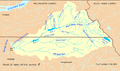 | 710 × 420 (64 KB) | Finetooth | Added location of the unincorporated community of Bull Run |
| 03:47, 10 January 2010 | 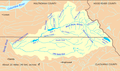 | 710 × 420 (82 KB) | Finetooth | {{Information |Description={{en|1=Map of Bull Run River (Oregon) watershed in Multnomah and Clackamas counties, Oregon, United States. The river begins near Mount Hood in the Cascade Range and flows into the Sandy River between the city of Sandy and the C |
File usage
The following pages on the English Wikipedia use this file (pages on other projects are not listed):
Global file usage
The following other wikis use this file:
- Usage on ru.wikipedia.org
- Usage on www.wikidata.org