
File:Bulgaria and Romania 1887.png

Size of this preview: 726 × 600 pixels. Other resolutions: 291 × 240 pixels | 581 × 480 pixels | 930 × 768 pixels | 1,185 × 979 pixels.
Original file (1,185 × 979 pixels, file size: 139 KB, MIME type: image/png)
| This is a file from the Wikimedia Commons. Information from its description page there is shown below. Commons is a freely licensed media file repository. You can help. |
Summary
| Description |
English: Locator map of a hypothetical union between Bulgaria and Romania, plausible in 1887. Eastern Rumelia is also included. |
|||
| Date | ||||
| Source | File:Kingdom of Romania (1890).svg | |||
| Author |
TRAJAN 117 (original image) Super Dromaeosaurus (derivative work) |
|||
| Other versions |
|


Licensing
This file is licensed under the Creative Commons Attribution-Share Alike 4.0 International license.
- You are free:
- to share – to copy, distribute and transmit the work
- to remix – to adapt the work
- Under the following conditions:
- attribution – You must give appropriate credit, provide a link to the license, and indicate if changes were made. You may do so in any reasonable manner, but not in any way that suggests the licensor endorses you or your use.
- share alike – If you remix, transform, or build upon the material, you must distribute your contributions under the same or compatible license as the original.
File history
Click on a date/time to view the file as it appeared at that time.
| Date/Time | Thumbnail | Dimensions | User | Comment | |
|---|---|---|---|---|---|
| current | 21:16, 6 March 2021 | 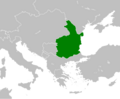 | 1,185 × 979 (139 KB) | Super Dromaeosaurus | added lakes |
| 10:31, 15 July 2020 |  | 1,185 × 979 (135 KB) | Super Dromaeosaurus | Uploaded a work by User:TRAJAN 117 (original image) User:Super Dromaeosaurus (derivative work) from File:Kingdom of Romania (1890).svg with UploadWizard |
.svg)
File usage
The following pages on the English Wikipedia use this file (pages on other projects are not listed):
- Union of Bulgaria and Romania
- User:Gog the Mild/Blurbs/Archive 1
- Wikipedia:Main Page history/2021 May 14
- Wikipedia:Main Page history/2021 May 14b
- Wikipedia:Today's featured article/May 14, 2021
- Wikipedia:Today's featured article/May 2021
- Wikipedia talk:Featured article candidates/Union of Bulgaria and Romania/archive1
Global file usage
The following other wikis use this file:
- Usage on ar.wikipedia.org
- Usage on fr.wikipedia.org
- Usage on id.wikipedia.org
- Usage on it.wikipedia.org
- Usage on ms.wikipedia.org
- Usage on ro.wikipedia.org
- Usage on zh.wikipedia.org