
File:Bruce Street after the 1935 Balochistan earthquake.jpg

No higher resolution available.
Bruce_Street_after_the_1935_Balochistan_earthquake.jpg (576 × 339 pixels, file size: 22 KB, MIME type: image/jpeg)
| This is a file from the Wikimedia Commons. Information from its description page there is shown below. Commons is a freely licensed media file repository. You can help. |
| Description | An image detailing the destruction of Bruce Street, now Jinnah Road, in Quetta, after the earthquake that hit the city on 31 May 1935. | |||
| Date | ||||
| Source | I created this image entirely by myself. | |||
| Author | Harcourt James Waller | |||
| Permission (Reusing this file) |
|

| Object location | | View this and other nearby images on: OpenStreetMap |
|---|

|
Permission is granted to copy, distribute and/or modify this document under the terms of the GNU Free Documentation License, Version 1.2 or any later version published by the Free Software Foundation; with no Invariant Sections, no Front-Cover Texts, and no Back-Cover Texts. A copy of the license is included in the section entitled GNU Free Documentation License. |
| This file is licensed under the Creative Commons Attribution-Share Alike 3.0 Unported license. | ||
| ||
| This licensing tag was added to this file as part of the GFDL licensing update. |
File history
Click on a date/time to view the file as it appeared at that time.
| Date/Time | Thumbnail | Dimensions | User | Comment | |
|---|---|---|---|---|---|
| current | 11:26, 4 November 2008 | 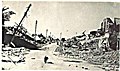 | 576 × 339 (22 KB) | Nick Anfinsen | {{Information |Description=An image detailing the destruction of Bruce Street, now the Jinnah Road in Quetta, after the earthquake that hit the city on 31 May 1935. |Source=I created this image entirely by myself. |Date=5 June,2008 |Author=Harcour |
File usage
The following pages on the English Wikipedia use this file (pages on other projects are not listed):
Global file usage
The following other wikis use this file:
- Usage on bn.wikipedia.org
- Usage on da.wikipedia.org
- Usage on fa.wikipedia.org
- Usage on fr.wikipedia.org
- Usage on ru.wikipedia.org