
File:Britain peoples circa 600.svg

Size of this PNG preview of this SVG file: 483 × 599 pixels. Other resolutions: 193 × 240 pixels | 387 × 480 pixels | 619 × 768 pixels | 825 × 1,024 pixels | 1,651 × 2,048 pixels | 994 × 1,233 pixels.
Original file (SVG file, nominally 994 × 1,233 pixels, file size: 1.88 MB)
| This is a file from the Wikimedia Commons. Information from its description page there is shown below. Commons is a freely licensed media file repository. You can help. |
| Description |
Deutsch: Landnahme der Angeln, Sachsen und Jüten auf den Britischen Inseln um das Jahr 600. English: Peoples of Britain circa 600. Español: Mapa da Bretanha ca. 600. Français : La Grande-Bretagne vers 600. Magyar: Brit népcsoportok 600 körül. Polski: Ludy Brytanii ok. 600 r. Português: Mapa da Bretanha ca. 600. 中文(中国大陆): 公元600年的不列颠。 |
||||||||
| Date | |||||||||
| Source |
Own work using:
|
||||||||
| Author | User:Hel-hama | ||||||||
| Permission (Reusing this file) |
|
||||||||
| Other versions |
[]
|


File history
Click on a date/time to view the file as it appeared at that time.
| Date/Time | Thumbnail | Dimensions | User | Comment | |
|---|---|---|---|---|---|
| current | 16:03, 8 July 2012 |  | 994 × 1,233 (1.88 MB) | Hel-hama | coastline and text modified |
| 10:42, 17 June 2012 |  | 973 × 1,268 (4.16 MB) | Hel-hama | Revised version of map using Shepherd's original version from http://www.lib.utexas.edu/maps/historical/history_shepherd_1923.html | |
| 20:58, 2 September 2008 | 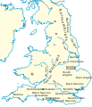 | 944 × 1,104 (362 KB) | Wereon | {{Information |Description= |Source= |Date= |Author= |Permission= |other_versions= }} | |
| 20:57, 2 September 2008 |  | 944 × 1,104 (362 KB) | Wereon | . <!--{{ImageUpload|basic}}--> |
File usage
The following pages on the English Wikipedia use this file (pages on other projects are not listed):
- 596
- Angles (tribe)
- Anglo-Saxons
- Augustine of Canterbury
- British Latin
- Burial in Anglo-Saxon England
- Cwichelm of Wessex
- Cynegils
- Edwin of Northumbria
- England–Wales border
- English people
- Eorpwald of East Anglia
- Genetic history of the British Isles
- Gregorian mission
- History of Anglo-Saxon England
- History of England
- Kingdom of Lindsey
- Magic in Anglo-Saxon England
- Medeshamstede
- Oswald of Northumbria
- Oswiu
- Penda of Mercia
- People of the British Isles
- Rædwald of East Anglia
- Sigeberht of East Anglia
- Snape Anglo-Saxon Cemetery
- Street House Anglo-Saxon cemetery
- Æthelfrith
- Talk:East Anglia
- User:Abyssal/bla
- User:Cop 663/English
- User:Doug Weller/Ancestry of the kings of Britain
- User:Dudley Miles/sandbox
- User:MathewTownsend/Images/maps
- User:SrAtoz/Penda de Mércia
- User:Wobble/pa
- Portal:Christianity/Selected article/2009
- Portal:Christianity/Selected article/July 2009
- Portal:England
Global file usage
The following other wikis use this file:
- Usage on am.wikipedia.org
- Usage on ang.wikipedia.org
- Usage on ar.wikipedia.org
- Usage on arz.wikipedia.org
- Usage on azb.wikipedia.org
- Usage on be-tarask.wikipedia.org
- Usage on br.wikipedia.org
- Usage on ca.wikipedia.org
- Usage on cs.wikipedia.org
- Usage on da.wikipedia.org
- Usage on de.wikipedia.org
- Usage on el.wikipedia.org
- Usage on et.wikipedia.org
- Usage on eu.wikipedia.org
- Usage on fa.wikipedia.org
- Usage on fi.wikipedia.org
- Usage on fr.wikipedia.org
- Usage on fy.wikipedia.org
- Usage on got.wikipedia.org
- Usage on hr.wikipedia.org
View more global usage of this file.