
File:Bristol Temple Meads from Bath Road bridge.jpg

Size of this preview: 800 × 533 pixels. Other resolutions: 320 × 213 pixels | 640 × 426 pixels | 1,024 × 682 pixels | 1,366 × 910 pixels.
Original file (1,366 × 910 pixels, file size: 425 KB, MIME type: image/jpeg)
| This is a file from the Wikimedia Commons. Information from its description page there is shown below. Commons is a freely licensed media file repository. You can help. |
Summary
| Description |
English: Temple Meads station, Bristol, England. Viewed from Bath Road bridge, the CrossCountry Voyager train is leaving Platform 4 on a Manchester Piccadilly to Paignton working.
Deutsch: Temple Meads Station, Bristol, England. Angesehen von Bath Road Bridge, die CrossCountry Voyager-Zug, der Platform 4 auf einem Manchester Piccadilly zu Paignton arbeiten.
日本語: テンプルミーズ駅、ブリストル、イギリス。バス道路の橋から見て、クロスカントリーボイジャーの列車はペイントンの作業にマンチェスターピカデリーのプラットフォーム4を残している。 |
| Date | |
| Source | Own work |
| Author | Geof Sheppard |
Licensing
I, the copyright holder of this work, hereby publish it under the following licenses:
This file is licensed under the Creative Commons Attribution-Share Alike 4.0 International license.
- You are free:
- to share – to copy, distribute and transmit the work
- to remix – to adapt the work
- Under the following conditions:
- attribution – You must give appropriate credit, provide a link to the license, and indicate if changes were made. You may do so in any reasonable manner, but not in any way that suggests the licensor endorses you or your use.
- share alike – If you remix, transform, or build upon the material, you must distribute your contributions under the same or compatible license as the original.

|
Permission is granted to copy, distribute and/or modify this document under the terms of the GNU Free Documentation License, Version 1.2 or any later version published by the Free Software Foundation; with no Invariant Sections, no Front-Cover Texts, and no Back-Cover Texts. A copy of the license is included in the section entitled GNU Free Documentation License. |
You may select the license of your choice.
| Camera location | | View this and other nearby images on: OpenStreetMap |
|---|
File history
Click on a date/time to view the file as it appeared at that time.
| Date/Time | Thumbnail | Dimensions | User | Comment | |
|---|---|---|---|---|---|
| current | 21:04, 14 January 2023 |  | 1,366 × 910 (425 KB) | Geof Sheppard | Larger copy |
| 05:36, 10 December 2011 | 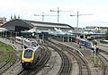 | 800 × 559 (147 KB) | Mattbuck | Old version looks better - new one is too contrasty | |
| 05:21, 10 December 2011 | 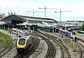 | 800 × 559 (154 KB) | Clarkcj12 | Improved Brightness. | |
| 07:20, 18 June 2008 |  | 800 × 559 (147 KB) | Geof Sheppard | {{Information |Description=Temple Meads station, Bristol, England. Viewed from Bath Road bridge, the CrossCountry Voyager train is leaving Platform 4 on a Manchester Piccadilly to Paignton working. |Source=self-made |Date=14 June 2008 |Author= [[User:Geo |
File usage
The following pages on the English Wikipedia use this file (pages on other projects are not listed):
Global file usage
The following other wikis use this file:
- Usage on de.wikipedia.org
- Usage on fa.wikipedia.org
- Usage on ja.wikipedia.org