
File:Brenda 1960-07-30 weather map.jpg
No higher resolution available.
Brenda_1960-07-30_weather_map.jpg (600 × 578 pixels, file size: 60 KB, MIME type: image/jpeg)
| This is a file from the Wikimedia Commons. Information from its description page there is shown below. Commons is a freely licensed media file repository. You can help. |
Summary
| Description | ||||
| Date | ||||
| Source | NOAA Central Library Data Imaging Project | |||
| Author | NOAA Central Library, Silver Spring, Maryland | |||
| Permission (Reusing this file) |
|
File history
Click on a date/time to view the file as it appeared at that time.
| Date/Time | Thumbnail | Dimensions | User | Comment | |
|---|---|---|---|---|---|
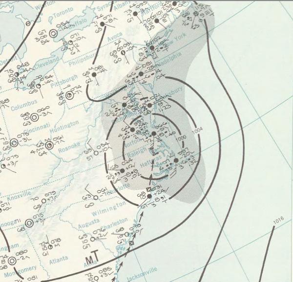
| current | 18:20, 5 January 2010 |  | 600 × 578 (60 KB) | Juliancolton | {{Information |Description={{en|1=A July 30, 1960 weather map of a storm.}} |Source=http://docs.lib.noaa.gov/rescue/dwm/1960/19600730.djvu |Author=[http://docs.lib.noaa.gov/rescue/dwm/data_rescue_daily_weather_maps.html NOAA Central Library Data Imaging P |
File usage
The following pages on the English Wikipedia use this file (pages on other projects are not listed):
Global file usage
The following other wikis use this file:
- Usage on es.wikipedia.org
- Usage on fr.wikipedia.org
- Usage on pt.wikipedia.org
- Usage on ro.wikipedia.org
- Usage on vi.wikipedia.org
- Usage on zh.wikipedia.org