
File:Bougainville Operation map.jpg

Original file (562 × 798 pixels, file size: 158 KB, MIME type: image/jpeg)
| This is a file from the Wikimedia Commons. Information from its description page there is shown below. Commons is a freely licensed media file repository. You can help. |
Summary
| Description |
English: Map of Japanese troop movements on Bougainville during the fighting on the island between November 1943 and March 1944 |
| Date | Created in or prior to 1950, first published in 1966 |
| Source | Reports of General MacArthur: JAPANESE OPERATIONS IN THE SOUTHWEST PACIFIC AREA. VOLUME II - PART I. Archived from the original on 4 March 2016. Retrieved on 9 April 2012. |
| Author | Not stated. The materials were provided to the US Army by the Japanese Demobilization Bureaux. The book was commissioned and published by the US Army |
Licensing
| According to Japanese Copyright Law (June 1, 2018 grant), the work is now in the public domain in Japan because the copyrights of the works in names of organizations, in Japan expire in 50 years after the publication, or in 50 years after the creation if the works are not published within 50 years after the creation (article 53).
To uploader: Please provide a name of organization and year of publication and source.
Note: The enforcement of the revised Copyright Act on December 30, 2018 extended the copyright term of works whose copyright was valid on that day to 70 years. Do not use this template for works published after 1967. Please note that being in the public domain in Japan does not automatically mean that it is free as well in the United States. Find and add one of the PD US license tags in order to ensure that the file is free in the United States. Typically, for a published work to be in the public domain in the United States, it needs to be published before 1946, because of URAA-restored copyrights. Unpublished works need to satisfy {{PD-US-unpublished}}.
|

|
File history
Click on a date/time to view the file as it appeared at that time.
| Date/Time | Thumbnail | Dimensions | User | Comment | |
|---|---|---|---|---|---|
| current | 15:31, 1 April 2017 | 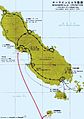 | 562 × 798 (158 KB) | Hohum | Reverted to version as of 15:26, 1 April 2017 (UTC) |
| 15:27, 1 April 2017 | 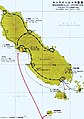 | 562 × 798 (155 KB) | Hohum | Slightly brighter | |
| 15:26, 1 April 2017 |  | 562 × 798 (158 KB) | Hohum | Reworked colours | |
| 15:09, 19 May 2016 |  | 562 × 798 (152 KB) | Hohum | Cleanup | |
| 01:48, 9 April 2012 |  | 562 × 798 (98 KB) | Nick-D | {{Information |Description ={{en|1=Map of Japanese troop movements on Bougainville during the fighting on the island between November 1943 and March 1944}} |Source =http://www.history.army.mil/books/wwii/MacArthur%20Reports/MacArthur%20V2%20... |
File usage
Global file usage
The following other wikis use this file:
- Usage on de.wikipedia.org
- Usage on fr.wikipedia.org
- Usage on hu.wikipedia.org
- Usage on ru.wikipedia.org