
File:Boring lava allen map.png

Size of this preview: 517 × 599 pixels. Other resolutions: 207 × 240 pixels | 414 × 480 pixels | 690 × 800 pixels.
Original file (690 × 800 pixels, file size: 31 KB, MIME type: image/png)
| This is a file from the Wikimedia Commons. Information from its description page there is shown below. Commons is a freely licensed media file repository. You can help. |
Summary
| Description |
English: Map of the Boring Lava Field in Oregon and southwest Washington
Legend: 1. Green Mountain 2. Brunner Hill (2 vents) 3. Prune Hill (West) 4. Prune Hill (East) 5. Mount Norway (2 vents) 6. Nochol's Hill 7. Bear Prairie 8. Pohl's Mountain 9. Bob's Mountain (South) 10. Bob's Mountain (North) 14. Mount Pleasant 15. Mount Zion 21. TV Hill 22. Swede Hill 24. Elk Point (2 vents) 25. Mount Sylvania (2 vents) 26. Cook's Butte (2 vents) 27. Mount Tabor 28. Rocky Butte (2 vents) 29. Kelly Butte (2 vents) 30. Chamberlain Hill 31. Ross Mountain 32. Pepper Mountain (2 vents) 33. Devil's Rest (2 vents) 34. Larch Mountain 36. Palmer Peak 37. Nesmith Point 40. Walker Peak 41. Lookout Point 42. Powell Butte 43. Mount Scott (2 vents) 44. Willamette National Cemetery 46. Scout Camp (2 vents) 48. Mount Talbert 69. Hunsinger Peak 73. Highland Butte (4 vents)74. Lenhart Butte |
| Date | |
| Source | http://vulcan.wr.usgs.gov/Volcanoes/Oregon/Publications/Allen1975/boring_lava_allen_table.html |
| Author | Lyn Topinka; modified from: Allen, 1975, Volcanoes of the Portland Area, Ore-Bin, v.37, no. 9 |
| Other versions | Allen, John E. (1975-09). "Volcanoes of the Portland Area, Oregon". The Ore Bin 37 (9): 152-153. Portland, Oregon: State of Oregon Department of Geology and Mineral Industries. |
Licensing
This work is in the public domain in the United States because it is a work prepared by an officer or employee of the United States Government as part of that person’s official duties under the terms of Title 17, Chapter 1, Section 105 of the US Code.
Note: This only applies to original works of the Federal Government and not to the work of any individual U.S. state, territory, commonwealth, county, municipality, or any other subdivision. This template also does not apply to postage stamp designs published by the United States Postal Service since 1978. (See § 313.6(C)(1) of Compendium of U.S. Copyright Office Practices). It also does not apply to certain US coins; see The US Mint Terms of Use.
|
 | |
| This file has been identified as being free of known restrictions under copyright law, including all related and neighboring rights. | ||
Original upload log
| Date/Time | Dimensions | User | Comment |
|---|---|---|---|
| 30 July 2009, 07:37:22 | 690 × 800 (34026 bytes) | Peteforsyth (talk · contribs) | {{Information |Description=Map of the [[en:Boring Lava Field|Boring Lava Field]] in Oregon and southwest Washington |Source=http://vulcan.wr.usgs.gov/Volcanoes/Oregon/Publications/Allen1975/boring_lava_allen_table.html |Date= |Author= |Permission= |other_ |
File history
Click on a date/time to view the file as it appeared at that time.
| Date/Time | Thumbnail | Dimensions | User | Comment | |
|---|---|---|---|---|---|
| current | 21:17, 24 August 2014 | 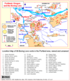 | 690 × 800 (31 KB) | GifTagger | Bot: Converting file to superior PNG file. (Source: Boring_lava_allen_map.gif). This GIF was problematic due to non-greyscale color table. |
File usage
The following pages on the English Wikipedia use this file (pages on other projects are not listed):