
File:Big Butte Creek Watershed.png

Size of this preview: 715 × 600 pixels. Other resolutions: 286 × 240 pixels | 572 × 480 pixels | 915 × 768 pixels | 1,162 × 975 pixels.
Original file (1,162 × 975 pixels, file size: 1.64 MB, MIME type: image/png)
| This is a file from the Wikimedia Commons. Information from its description page there is shown below. Commons is a freely licensed media file repository. You can help. |
Summary
| Description | |
| Date | |
| Source | Map taken from the Demis Map Server and modified by Little Mountain 5. Watershed boundaries taken from here. |
| Author | Demis Map Server, Little Mountain 5 |
Licensing
I, the copyright holder of this work, hereby publish it under the following licenses:
This file is licensed under the Creative Commons Attribution-Share Alike 3.0 Unported license.
- You are free:
- to share – to copy, distribute and transmit the work
- to remix – to adapt the work
- Under the following conditions:
- attribution – You must give appropriate credit, provide a link to the license, and indicate if changes were made. You may do so in any reasonable manner, but not in any way that suggests the licensor endorses you or your use.
- share alike – If you remix, transform, or build upon the material, you must distribute your contributions under the same or compatible license as the original.

|
Permission is granted to copy, distribute and/or modify this document under the terms of the GNU Free Documentation License, Version 1.2 or any later version published by the Free Software Foundation; with no Invariant Sections, no Front-Cover Texts, and no Back-Cover Texts. A copy of the license is included in the section entitled GNU Free Documentation License. |
You may select the license of your choice.
File history
Click on a date/time to view the file as it appeared at that time.
| Date/Time | Thumbnail | Dimensions | User | Comment | |
|---|---|---|---|---|---|
| current | 23:19, 24 September 2011 |  | 1,162 × 975 (1.64 MB) | Little Mountain 5 | Better quality and minor fixes |
| 21:49, 21 August 2010 |  | 1,162 × 976 (1.63 MB) | Little Mountain 5 | Change background, minor fixes | |
| 19:25, 7 August 2010 | 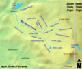 | 1,164 × 975 (1.61 MB) | Little Mountain 5 | Minor fixes | |
| 15:07, 26 April 2010 | 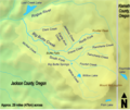 | 1,164 × 982 (1.6 MB) | Little Mountain 5 | Clean up text a bit | |
| 14:34, 5 April 2010 | 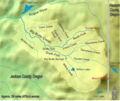 | 1,164 × 982 (2.65 MB) | Graham Beards | Made labels more legible | |
| 18:33, 6 March 2010 | 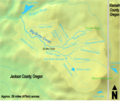 | 1,164 × 982 (1.59 MB) | Little Mountain 5 | Darken name | |
| 15:25, 16 February 2010 |  | 1,164 × 975 (1.59 MB) | Little Mountain 5 | New, better background | |
| 15:44, 12 February 2010 |  | 1,181 × 968 (236 KB) | Little Mountain 5 | {{Information |Description={{en|1=A map of the Big Butte Creek watershed}} |Source=Map taken from the US Census website listed below this template and modified by Little Mountain 5. Watershed boundaries tak |
File usage
The following pages on the English Wikipedia use this file (pages on other projects are not listed):
Global file usage
The following other wikis use this file:
- Usage on fr.wikipedia.org
- Usage on pt.wikipedia.org
- Usage on www.wikidata.org