
File:BeforeDayton.png

Size of this preview: 619 × 599 pixels. Other resolutions: 248 × 240 pixels | 496 × 480 pixels | 793 × 768 pixels | 1,057 × 1,024 pixels | 1,809 × 1,752 pixels.
Original file (1,809 × 1,752 pixels, file size: 161 KB, MIME type: image/png)
| This is a file from the Wikimedia Commons. Information from its description page there is shown below. Commons is a freely licensed media file repository. You can help. |
Summary
| Description |
English: Lines of control before Dayton agreement
Hrvatski: Linije bojišta prije daytonskog sporazuma |
| Date | |
| Source | Own work |
| Author | Ceha |

|
This historical map image could be re-created using vector graphics as an SVG file. This has several advantages; see Commons:Media for cleanup for more information. If an SVG form of this image is available, please upload it and afterwards replace this template with
{{vector version available|new image name}}.
It is recommended to name the SVG file “BeforeDayton.svg”—then the template Vector version available (or Vva) does not need the new image name parameter. |
Licensing
| I, the copyright holder of this work, release this work into the public domain. This applies worldwide. In some countries this may not be legally possible; if so: I grant anyone the right to use this work for any purpose, without any conditions, unless such conditions are required by law. |
File history
Click on a date/time to view the file as it appeared at that time.
| Date/Time | Thumbnail | Dimensions | User | Comment | |
|---|---|---|---|---|---|
| current | 12:57, 13 February 2022 |  | 1,809 × 1,752 (161 KB) | Ceha | Brčko |
| 23:37, 24 January 2022 |  | 1,809 × 1,752 (161 KB) | Ceha | Žepče | |
| 23:29, 24 January 2022 |  | 1,809 × 1,752 (161 KB) | Ceha | Jugoistočno Brčko | |
| 14:56, 23 January 2022 |  | 1,809 × 1,752 (161 KB) | Ceha | Oko Bihaća | |
| 02:37, 14 March 2020 | 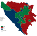 | 1,809 × 1,752 (161 KB) | Ceha | *Southern and western pockets around Bihać (Lika Villages and beyond Una) *eastern borders of Bočac and Banja Luka and Kneževo villages under HVO control | |
| 14:22, 19 May 2017 |  | 1,809 × 1,752 (160 KB) | Ceha | Uskoplje, Rama | |
| 14:16, 19 May 2017 |  | 1,809 × 1,752 (160 KB) | Ceha | HV also conquered Bočac | |
| 19:46, 2 December 2016 |  | 1,809 × 1,752 (78 KB) | Srđan | colorblind friendly | |
| 13:24, 7 February 2015 |  | 1,809 × 1,752 (160 KB) | Ceha | Ispravio linije po središnjoj Bosni i sjevernoj Hercegovini. | |
| 09:05, 2 December 2014 |  | 1,809 × 1,752 (223 KB) | Ceha | rv (colors) |
File usage
The following pages on the English Wikipedia use this file (pages on other projects are not listed):
Global file usage
The following other wikis use this file:
- Usage on an.wikipedia.org
- Usage on ar.wikipedia.org
- Usage on azb.wikipedia.org
- Usage on bs.wikipedia.org
- Usage on da.wikipedia.org
- Usage on es.wikipedia.org
- Usage on fa.wikipedia.org
- Usage on fi.wikipedia.org
- Usage on fr.wikipedia.org
- Usage on hr.wikipedia.org
- Usage on hu.wikipedia.org
- Usage on id.wikipedia.org
- Usage on ko.wikipedia.org
- Usage on mk.wikipedia.org
- Usage on ms.wikipedia.org
- Usage on pt.wikipedia.org
- Usage on ru.wikipedia.org
- Usage on sh.wikipedia.org
- Usage on sr.wikipedia.org
- Usage on tr.wikipedia.org
- Usage on uk.wikipedia.org