
File:Beaverflood.JPG
Beaverflood.JPG (469 × 324 pixels, file size: 35 KB, MIME type: image/jpeg)
| This is a file from the Wikimedia Commons. Information from its description page there is shown below. Commons is a freely licensed media file repository. You can help. |
| Description |
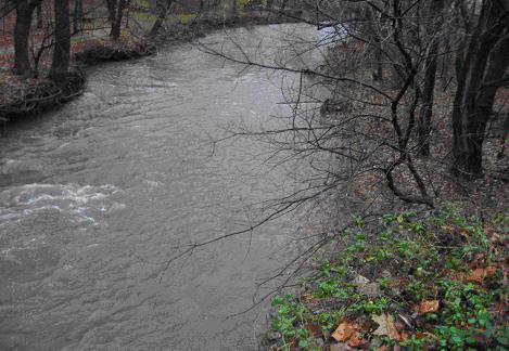
English: The Beaver Creek at the NIRM preserve is seen here. This was taken after a sizeable rainfall event that came through the Amherst area. As it can be seen, the Creek is almost utilizing its floodplain on the right side of the photograph. Floodplains are important, natural areas that hold and cleanse flood waters before slowly releasing them into the watercourse. These areas should not be built upon. Also, all creeks and rivers should have a “riparian area” on both sides of the watercourse that is left natural and not tampered with by human activities like mowing, building, and land-clearing. These strips of land on the sides of a creek or river are important in cleaning and slowing down water before it enters the watercourse. Also, they help in protecting the side of the banks from erosion. For a creek of Beaver Creek’s size, a riparian area of at least 120-150 feet is needed; a river for the size of the nearby Black River or Vermilion River needs a riparian area of about 300 feet. |
| Date | |
| Source | Own work |
| Author | 08milluz (talk) (Uploads) |
Summary
The Beaver Creek at the NIRM preserve is seen here. This was taken after a sizeable rainfall event that came through the Amherst area. As it can be seen, the Creek is almost utilizing its floodplain on the right side of the photograph. Floodplains are important, natural areas that hold and cleanse flood waters before slowly releasing them into the watercourse. These areas should not be built upon. Also, all creeks and rivers should have a “riparian area” on both sides of the watercourse that is left natural and not tampered with by human activities like mowing, building, and land-clearing. These strips of land on the sides of a creek or river are important in cleaning and slowing down water before it enters the watercourse. Also, they help in protecting the side of the banks from erosion. For a creek of Beaver Creek’s size, a riparian area of at least 120-150 feet is needed; a river for the size of the nearby Black River or Vermilion River needs a riparian area of about 300 feet.
Licensing
| I, the copyright holder of this work, release this work into the public domain. This applies worldwide. In some countries this may not be legally possible; if so: I grant anyone the right to use this work for any purpose, without any conditions, unless such conditions are required by law. |

|
This media file is uncategorized.
Please help improve this media file by adding it to one or more categories, so it may be associated with related media files (how?), and so that it can be more easily found.
Please notify the uploader with {{subst:Please link images|File:Beaverflood.JPG}} ~~~~ |
File history
Click on a date/time to view the file as it appeared at that time.
| Date/Time | Thumbnail | Dimensions | User | Comment | |
|---|---|---|---|---|---|
| current | 03:07, 29 November 2007 |  | 469 × 324 (35 KB) | 08milluz | The Beaver Creek at the NIRM preserve is seen here. This was taken after a sizeable rainfall event that came through the Amherst area. As it can be seen, the Creek is almost utilizing its floodplain on the right side of the photograph. Floodplains are |