
File:Bear Mountain Road.jpg

Size of this preview: 545 × 599 pixels. Other resolutions: 218 × 240 pixels | 437 × 480 pixels | 699 × 768 pixels | 932 × 1,024 pixels | 1,863 × 2,048 pixels | 2,748 × 3,020 pixels.
Original file (2,748 × 3,020 pixels, file size: 1.18 MB, MIME type: image/jpeg)
| This is a file from the Wikimedia Commons. Information from its description page there is shown below. Commons is a freely licensed media file repository. You can help. |
|
This is an image of a place or building that is listed on the National Register of Historic Places in the United States of America. Its reference number is 82001266. |
| Description | |||
| Date | |||
| Source | Own work | ||
| Author | Daniel Case | ||
| Permission (Reusing this file) |
Daniel Case at the English Wikipedia project, the copyright holder of this work, hereby publishes it under the following licenses:
This file is licensed under the Creative Commons Attribution-Share Alike 3.0 Unported license. Attribution: Daniel Case at the English Wikipedia project
You may select the license of your choice. |

| Object location | | View this and other nearby images on: OpenStreetMap |
|---|
File history
Click on a date/time to view the file as it appeared at that time.
| Date/Time | Thumbnail | Dimensions | User | Comment | |
|---|---|---|---|---|---|
| current | 22:50, 2 September 2009 | 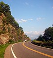 | 2,748 × 3,020 (1.18 MB) | Daniel Case | {{Information |Description={{en|1=Bear Mountain Bridge Road (US 6/202) on the slopes of Anthony's Nose}} |Source=Own work by uploader |Aut |
File usage
The following pages on the English Wikipedia use this file (pages on other projects are not listed):
Global file usage
The following other wikis use this file:
- Usage on www.wikidata.org