
File:Average Annual High Temperature of the United States.jpg
Size of this preview: 800 × 510 pixels. Other resolutions: 320 × 204 pixels | 640 × 408 pixels | 1,024 × 653 pixels | 1,280 × 816 pixels | 1,725 × 1,100 pixels.
Original file (1,725 × 1,100 pixels, file size: 318 KB, MIME type: image/jpeg)
| This is a file from the Wikimedia Commons. Information from its description page there is shown below. Commons is a freely licensed media file repository. You can help. |
Summary
| Description |
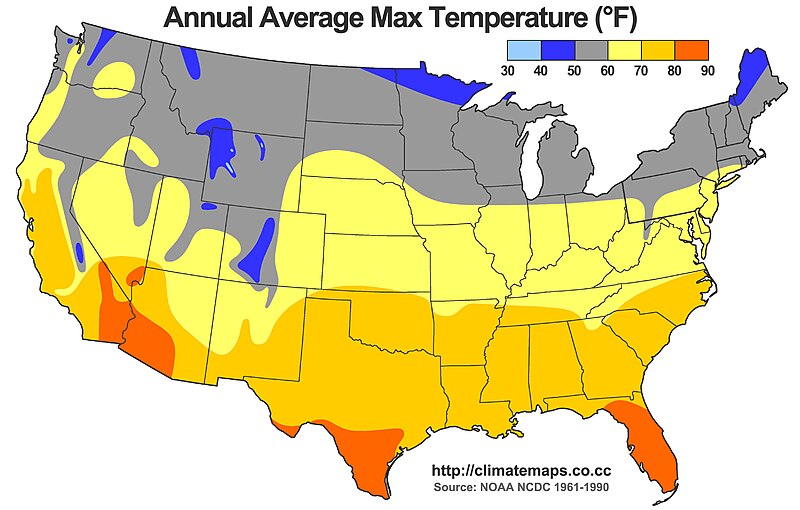
English: This map shows the average annual high temperature of the United States. The scale is displayed in units of degrees Fahrenheit, based on the following colors.
Light blue: 30-40°F Dark blue: 40-50°F Gray: 50-60°F Yellow: 60-70°F Light orange: 70-80°F Dark orange: 80-90°F All data are based on the National Climatic Data Center 1961-1990 dataset. Map created by Alex Matus - http://climatemaps.co.cc |
| Date | |
| Source | Own work |
| Author | Mamatus |
Licensing
I, the copyright holder of this work, hereby publish it under the following licenses:
This file is licensed under the Creative Commons Attribution-Share Alike 3.0 Unported license.
- You are free:
- to share – to copy, distribute and transmit the work
- to remix – to adapt the work
- Under the following conditions:
- attribution – You must give appropriate credit, provide a link to the license, and indicate if changes were made. You may do so in any reasonable manner, but not in any way that suggests the licensor endorses you or your use.
- share alike – If you remix, transform, or build upon the material, you must distribute your contributions under the same or compatible license as the original.

|
Permission is granted to copy, distribute and/or modify this document under the terms of the GNU Free Documentation License, Version 1.2 or any later version published by the Free Software Foundation; with no Invariant Sections, no Front-Cover Texts, and no Back-Cover Texts. A copy of the license is included in the section entitled GNU Free Documentation License. |
You may select the license of your choice.
File history
Click on a date/time to view the file as it appeared at that time.
| Date/Time | Thumbnail | Dimensions | User | Comment | |
|---|---|---|---|---|---|
| current | 16:34, 20 June 2011 |  | 1,725 × 1,100 (318 KB) | Mamatus | Legend improved. Color in New Jersey fixed. |
| 00:59, 20 June 2011 |  | 1,725 × 1,100 (520 KB) | Mamatus | {{Information |Description ={{en|1=This map shows the average annual high temperature of the United States. The scale is displayed in units of degrees Fahrenheit, based on the following colors. Light blue: 30-40°F Dark blue: 40-50°F Gray: 50-60°F |
File usage
The following pages on the English Wikipedia use this file (pages on other projects are not listed):
Global file usage
The following other wikis use this file:
- Usage on hu.wikipedia.org
- Usage on id.wikipedia.org