
File:Australia OpenRailway gauge map.agr.png

Size of this preview: 663 × 600 pixels. Other resolutions: 265 × 240 pixels | 531 × 480 pixels | 849 × 768 pixels | 1,132 × 1,024 pixels | 1,948 × 1,762 pixels.
Original file (1,948 × 1,762 pixels, file size: 1.24 MB, MIME type: image/png)
| This is a file from the Wikimedia Commons. Information from its description page there is shown below. Commons is a freely licensed media file repository. You can help. |
Summary
| Description |
English: Map of major Australian railways, color coded to show rail gauge. Screenshot of OpenRailwayMap.
1067 mm (3 ft 6 in) narrow gauge
1435 mm (4 ft 81⁄2 in) standard gauge
1600 mm (5 ft 3 in) broad gauge
The large network of narrow-gauge sugar cane light railways, almost all 610 mm (2 ft) gauge, is not shown. |
|||
| Date | 2 June 2022 | |||
| Source | openstreetmap.org | |||
| Creator |
OpenStreetMap contributors |
|||
| Permission (Reusing this file) |
OpenStreetMap data is available under the Open Database License (details). Standard style map tiles are licensed as ODbL Produced Works.
|
|||
| Georeferencing | If inappropriate please set warp_status = skip to hide. |
File history
Click on a date/time to view the file as it appeared at that time.
| Date/Time | Thumbnail | Dimensions | User | Comment | |
|---|---|---|---|---|---|
| current | 03:00, 28 December 2022 | 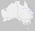 | 1,948 × 1,762 (1.24 MB) | SCHolar44 | Updated South Australia railway routes, added Croydon–Normanton railway, Queensland |
| 01:34, 3 June 2022 |  | 1,948 × 1,762 (1.5 MB) | ArnoldReinhold | {{OpenStreetMap |location = Australia |description = Map of Australian railways from OpenRailwayMap showing different track gauges. Black=standard gauge, Blue=narrow gauge, Orange=broad gauge |date = June2, 2022 |authors = OpenStreetMap contributors, user:ArnoldReinhold }} Category:Images by Arnold Reinhold Category:Maps of Australia Category:Rail transport maps of Western Australia |
File usage
The following pages on the English Wikipedia use this file (pages on other projects are not listed):
Global file usage
The following other wikis use this file:
- Usage on de.wikipedia.org