
File:ArabianSeaJune121977.png

Size of this preview: 496 × 600 pixels. Other resolutions: 198 × 240 pixels | 397 × 480 pixels | 991 × 1,198 pixels.
Original file (991 × 1,198 pixels, file size: 967 KB, MIME type: image/png)
| This is a file from the Wikimedia Commons. Information from its description page there is shown below. Commons is a freely licensed media file repository. You can help. |
Summary
| Description |
English: This weather satellite image of an Arabian Sea hurricane-force tropical cyclone was taken on June 12, 1977 |
| Date | |
| Source | Mariners Weather Log, September 1977, pg. 309 |
| Author | NOAA |
| Camera location | | View this and other nearby images on: OpenStreetMap |
|---|
Licensing
This image is in the public domain because it contains materials that originally came from the U.S. National Oceanic and Atmospheric Administration, taken or made as part of an employee's official duties.
|
Original upload log
| Date/Time | Dimensions | User | Comment |
|---|---|---|---|
| 30 April 2013, 03:17:00 | 991 × 1198 (999852 bytes) | Thegreatdr (talk · contribs) | User created page with UploadWizard |
File history
Click on a date/time to view the file as it appeared at that time.
| Date/Time | Thumbnail | Dimensions | User | Comment | |
|---|---|---|---|---|---|
| current | 19:46, 17 August 2014 | 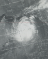 | 991 × 1,198 (967 KB) | GifTagger | Bot: Converting file to superior PNG file. (Source: ArabianSeaJune121977.gif). This GIF was problematic due to non-greyscale color table. |
File usage
The following pages on the English Wikipedia use this file (pages on other projects are not listed):
Global file usage
The following other wikis use this file:
- Usage on ar.wikipedia.org