
File:April 12–13, 2020 tornado outbreak warnings and reports.png

Size of this preview: 800 × 566 pixels. Other resolutions: 320 × 226 pixels | 640 × 453 pixels | 1,024 × 724 pixels | 1,280 × 905 pixels | 2,560 × 1,810 pixels | 3,507 × 2,480 pixels.
Original file (3,507 × 2,480 pixels, file size: 1.81 MB, MIME type: image/png)
| This is a file from the Wikimedia Commons. Information from its description page there is shown below. Commons is a freely licensed media file repository. You can help. |
Summary
| Description |
English: Map of confirmed tornadoes and tornado warnings issued by the National Weather Service from April 12 through April 13, 2020, over the southeastern United States and tornadoes confirmed and surveyed by the National Weather Service. Map produced in QGIS with border outlines from the United States Census Bureau. National Weather Service warning outlines available from the Iowa Environmental Mesonet and tornado data available from the National Weather Service. |
| Date | |
| Source | Own work |
| Author | TheAustinMan |
Licensing
I, the copyright holder of this work, hereby publish it under the following license:
This file is licensed under the Creative Commons Attribution-Share Alike 4.0 International license.
- You are free:
- to share – to copy, distribute and transmit the work
- to remix – to adapt the work
- Under the following conditions:
- attribution – You must give appropriate credit, provide a link to the license, and indicate if changes were made. You may do so in any reasonable manner, but not in any way that suggests the licensor endorses you or your use.
- share alike – If you remix, transform, or build upon the material, you must distribute your contributions under the same or compatible license as the original.
File history
Click on a date/time to view the file as it appeared at that time.
| Date/Time | Thumbnail | Dimensions | User | Comment | |
|---|---|---|---|---|---|
| current | 19:53, 27 May 2020 |  | 3,507 × 2,480 (1.81 MB) | TheAustinMan | Updated again |
| 03:25, 28 April 2020 |  | 3,507 × 2,480 (1.81 MB) | TheAustinMan | Updated | |
| 18:17, 24 April 2020 |  | 3,507 × 2,480 (1.81 MB) | TheAustinMan | Update | |
| 16:36, 22 April 2020 |  | 3,507 × 2,480 (1.81 MB) | TheAustinMan | Update | |
| 18:36, 18 April 2020 |  | 3,507 × 2,480 (1.81 MB) | TheAustinMan | Update | |
| 03:02, 17 April 2020 | 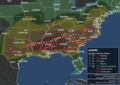 | 3,507 × 2,480 (1.8 MB) | TheAustinMan | Update and add tornado paths | |
| 00:10, 16 April 2020 | 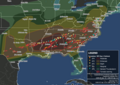 | 3,507 × 2,480 (1.77 MB) | TheAustinMan | Update | |
| 14:20, 15 April 2020 |  | 3,507 × 2,480 (1.74 MB) | TheAustinMan | Update | |
| 00:08, 15 April 2020 |  | 3,507 × 2,480 (1.71 MB) | TheAustinMan | Update and change date limits | |
| 04:21, 14 April 2020 |  | 3,507 × 2,480 (1.68 MB) | TheAustinMan | Uploaded own work with UploadWizard |
File usage
The following pages on the English Wikipedia use this file (pages on other projects are not listed):
Global file usage
The following other wikis use this file:
- Usage on ckb.wikipedia.org
- Usage on fr.wikipedia.org
- Usage on hr.wikipedia.org
- Usage on id.wikipedia.org
- Usage on ms.wikipedia.org
- Usage on pt.wikinews.org
- Usage on simple.wikipedia.org
- Usage on vi.wikipedia.org