
File:America map - Pact of Bogotá (signatures and ratifications).svg

Size of this PNG preview of this SVG file: 619 × 600 pixels. Other resolutions: 248 × 240 pixels | 495 × 480 pixels | 792 × 768 pixels | 1,057 × 1,024 pixels | 2,113 × 2,048 pixels | 1,945 × 1,885 pixels.
Original file (SVG file, nominally 1,945 × 1,885 pixels, file size: 535 KB)
| This is a file from the Wikimedia Commons. Information from its description page there is shown below. Commons is a freely licensed media file repository. You can help. |
| Description |
English: Signatory and member states of the Pact of Bogotá which was signed on April 30, 1948 and which is part of the legal framework of the Organization of American States (OAS).
Color legend:
Español: Estados signatarios y miembros del Pacto de Bogotá que se firmó el 30 de abril de 1948 y que forma parte del marco legal de la Organización de los Estados Americanos (OEA).
Colores:
Deutsch: Unterzeichner- und Vertragsstaaten des Bogotá-Pakts, der am 30. April 1948 unterzeichnet wurde und ein Teil der Rechtsgrundlagen der Organisation Amerikanischer Staaten (OAS) ist.
Farbenlegende:
|
| Date | (UTC) |
| Source | |
| Author |
| This is a retouched picture, which means that it has been digitally altered from its original version. Modifications: Changed color of countries according to their status regarding the Pact of Bogotá, removed territories which are not related to the Organization of American States. The original can be viewed here: America-blank-map-01.svg:
|
I, the copyright holder of this work, hereby publish it under the following licenses:

|
This work, previously under Public Domain, or a Free License has been digitally enhanced, I the creator of this work, hereby grant the permission to copy, distribute and/or modify this document under the terms of the GNU Free Documentation License, Version 1.2 or any later version published by the Free Software Foundation; with no Invariant Sections, no Front-Cover Texts, and no Back-Cover Texts. |
| This file is licensed under the Creative Commons Attribution-Share Alike 3.0 Unported license. | ||
| ||
| This licensing tag was added to this file as part of the GFDL licensing update. |
| I, the copyright holder of this work, release this work into the public domain. This applies worldwide. In some countries this may not be legally possible; if so: I grant anyone the right to use this work for any purpose, without any conditions, unless such conditions are required by law. |
You may select the license of your choice.
Original upload log
This image is a derivative work of the following images:
- File:America-blank-map-01.svg licensed with GFDL-retouched, PD-self
- 2009-03-20T02:16:16Z DavoO 1945x1885 (635478 Bytes) size
- 2008-12-20T20:23:15Z XZise 389x377 (625862 Bytes) New version based on [[:File:BlankMap-World6.svg]] instead.
- 2008-12-17T16:47:51Z XZise 878x1192 (573437 Bytes) {{Information |Description={{de|Leere politische Karte Amerikas}} {{en|Blank Politic Map of America}} |Source=[[:Image:World Map Blank.svg]] (Source: [[:Image:World map pol 2005 v02.svg]]) {{Inkscape}}{{ValidSVG}} |Date=16:46
- 2008-02-08T18:40:41Z CarolSpears 878x1192 (664152 Bytes) version that validates
- 2006-04-14T14:53:39Z Haylli 878x1192 (665496 Bytes) [[Category:SVG maps]]
Uploaded with derivativeFX
File history
Click on a date/time to view the file as it appeared at that time.
| Date/Time | Thumbnail | Dimensions | User | Comment | |
|---|---|---|---|---|---|
| current | 00:31, 3 October 2018 |  | 1,945 × 1,885 (535 KB) | Janitoalevic | Colombia |
| 13:33, 4 March 2012 |  | 1,945 × 1,885 (535 KB) | UW | Changed color of Bolivia from light green (signatory state) to dark green (member state) following ratification of the treaty by Bolivia in April 2011 | |
| 12:48, 16 July 2009 | 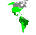 | 1,945 × 1,885 (530 KB) | UW | Modified version of an already existing image; changed colors | |
| 14:24, 15 July 2009 |  | 1,945 × 1,885 (529 KB) | UW | {{Information |Description=Signatory and member states of the Pact of Bogotá which was signied on April 30, 1948 and which is part of the legal framework of the Organization of American States (OAS). Color legend: * Green - States which have ratified the |
File usage
The following pages on the English Wikipedia use this file (pages on other projects are not listed):
Global file usage
The following other wikis use this file:
- Usage on de.wikipedia.org
- Usage on fr.wikipedia.org
- Usage on ja.wikipedia.org