
File:Al-Bayda Offensive (2020).svg

Size of this PNG preview of this SVG file: 533 × 599 pixels. Other resolutions: 213 × 240 pixels | 427 × 480 pixels | 683 × 768 pixels | 911 × 1,024 pixels | 1,821 × 2,048 pixels | 2,291 × 2,576 pixels.
Original file (SVG file, nominally 2,291 × 2,576 pixels, file size: 5.84 MB)
| This is a file from the Wikimedia Commons. Information from its description page there is shown below. Commons is a freely licensed media file repository. You can help. |
Summary
| Description |
English: Map of the Houthi-led Al-Bayda offensive which sought to expel Al-Qaeda/ISIS from the region and increase pressure on Hadi-held Ma'rib. Credit goes to Suriyak (https://twitter.com/suriyakmaps) and IWN (https://twitter.com/a7_mirza). |
| Date | |
| Source | Own work |
| Author | Rr016 |
Licensing
| Description |
This map was created from OpenStreetMap project data, collected by the community. This map may be incomplete, and may contain errors. Don't rely solely on it for navigation. |
|||
| Date | (see file history) | |||
| Source | openstreetmap.org | |||
| Creator |
OpenStreetMap contributors |
|||
| Permission (Reusing this file) |
OpenStreetMap data is available under the Open Database License (details). Map tiles are licensed under the Creative Commons Attribution-ShareAlike 2.0 license (CC-BY-SA 2.0).
This file is licensed under the Creative Commons Attribution-Share Alike 2.0 Generic license.
|
|||
| Georeferencing | If inappropriate please set warp_status = skip to hide. |
I, the copyright holder of this work, hereby publish it under the following license:
This file is licensed under the Creative Commons Attribution-Share Alike 4.0 International license.
- You are free:
- to share – to copy, distribute and transmit the work
- to remix – to adapt the work
- Under the following conditions:
- attribution – You must give appropriate credit, provide a link to the license, and indicate if changes were made. You may do so in any reasonable manner, but not in any way that suggests the licensor endorses you or your use.
- share alike – If you remix, transform, or build upon the material, you must distribute your contributions under the same or compatible license as the original.
File history
Click on a date/time to view the file as it appeared at that time.
| Date/Time | Thumbnail | Dimensions | User | Comment | |
|---|---|---|---|---|---|
| current | 18:18, 6 December 2020 |  | 2,291 × 2,576 (5.84 MB) | Rr016 | Update: Houthi-led advances prior to the front stagnating |
| 18:57, 15 September 2020 | 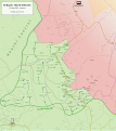 | 2,291 × 2,576 (5.74 MB) | Rr016 | Update: Houthi-led advances along the road towards Ma'rib | |
| 18:29, 24 August 2020 | 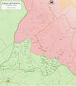 | 2,291 × 2,576 (5.68 MB) | Rr016 | Uploaded own work with UploadWizard |
File usage
The following pages on the English Wikipedia use this file (pages on other projects are not listed):
Global file usage
The following other wikis use this file:
- Usage on ar.wikipedia.org
- Usage on cs.wikipedia.org
- Usage on pt.wikipedia.org