
File:Aerial view of the U.S. Naval Air Station Cubi Point, Philippines, on 6 February 1988 (6482943).jpg

Size of this preview: 799 × 600 pixels. Other resolutions: 320 × 240 pixels | 640 × 480 pixels | 1,023 × 768 pixels | 1,280 × 961 pixels | 2,560 × 1,922 pixels | 3,000 × 2,252 pixels.
Original file (3,000 × 2,252 pixels, file size: 2.2 MB, MIME type: image/jpeg)
| This is a file from the Wikimedia Commons. Information from its description page there is shown below. Commons is a freely licensed media file repository. You can help. |
Summary
| Description |
English: An aerial view of the runway and flight line of the U.S. Naval Air Station Cubi Point, Philippines, on 6 February 1988. |
|||
| Date | ||||
| Source |
|
|||
| Author | PH2(NAC) David Sanner, U.S. Navy |
| Camera location | | View this and other nearby images on: OpenStreetMap |
|---|
Licensing
This file is a work of a sailor or employee of the U.S. Navy, taken or made as part of that person's official duties. As a work of the U.S. federal government, it is in the public domain in the United States.
|
 | |
| This file has been identified as being free of known restrictions under copyright law, including all related and neighboring rights. | ||
Original upload log
The original description page was here. All following user names refer to en.wikipedia.
- 2006-08-25 12:43 SunKing 3000×2252× (2304748 bytes) ID: DNSC9300780 Service Depicted: Navy An aerial view of the runway and flight line. Location: NAVAL AIR STATION, CUBI POINT, LUZON PHILIPPINES (PHL) Camera Operator: PH2(NAC) DAVID SANNER Date Shot: 6 Feb 1988 {{PD-USGov-Military-Navy}}
File history
Click on a date/time to view the file as it appeared at that time.
| Date/Time | Thumbnail | Dimensions | User | Comment | |
|---|---|---|---|---|---|
| current | 11:50, 5 June 2011 | 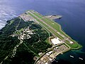 | 3,000 × 2,252 (2.2 MB) | File Upload Bot (Magnus Manske) | {{BotMoveToCommons|en.wikipedia|year={{subst:CURRENTYEAR}}|month={{subst:CURRENTMONTHNAME}}|day={{subst:CURRENTDAY}}}} {{Information |Description={{en|ID: DNSC9300780 Service Depicted: Navy An aerial view of the runway and flight line. Location: NAVA |
File usage
The following pages on the English Wikipedia use this file (pages on other projects are not listed):
Global file usage
The following other wikis use this file:
- Usage on ceb.wikipedia.org
- Usage on es.wikipedia.org
- Usage on eu.wikipedia.org
- Usage on fa.wikipedia.org
- Usage on fr.wikipedia.org
- Usage on hu.wikipedia.org
- Usage on id.wikipedia.org
- Usage on it.wikipedia.org
- Usage on ja.wikipedia.org
- Usage on ms.wikipedia.org
- Usage on nl.wikipedia.org
- Usage on pl.wikipedia.org
- Usage on sv.wikipedia.org
- Usage on th.wikipedia.org
- Usage on tl.wikipedia.org
- Usage on vi.wikipedia.org
- Usage on www.wikidata.org