
File:Able 1950-08-19 weather map.jpg
No higher resolution available.
Able_1950-08-19_weather_map.jpg (666 × 435 pixels, file size: 46 KB, MIME type: image/jpeg)
| This is a file from the Wikimedia Commons. Information from its description page there is shown below. Commons is a freely licensed media file repository. You can help. |
Summary
| Description | ||||
| Date | ||||
| Source | NOAA Central Library Data Imaging Project | |||
| Author | NOAA Central Library, Silver Spring, Maryland | |||
| Permission (Reusing this file) |
|
File history
Click on a date/time to view the file as it appeared at that time.
| Date/Time | Thumbnail | Dimensions | User | Comment | |
|---|---|---|---|---|---|
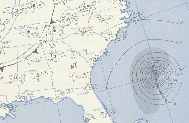
| current | 01:32, 30 August 2009 |  | 666 × 435 (46 KB) | Juliancolton | {{Information |Description={{en|1=A September 19, 1950 weather map featuring Hurricane Able}} |Source=http://docs.lib.noaa.gov/rescue/dwm/1950/19500819.djvu |Author=[http://docs.lib.noaa.gov/rescue/dwm/data_rescue_daily_weather_maps.html NOAA Central Libr |
File usage
The following pages on the English Wikipedia use this file (pages on other projects are not listed):
Global file usage
The following other wikis use this file:
- Usage on de.wikipedia.org
- Usage on es.wikipedia.org
- Usage on pt.wikipedia.org
- Usage on www.wikidata.org
- Usage on zh.wikipedia.org