
File:A boer war reenactor, MC Heunis preparing his heliograph on top of Elandskop Hill in Petrus Steyn.jpg

Size of this preview: 400 × 600 pixels. Other resolutions: 160 × 240 pixels | 320 × 480 pixels | 512 × 768 pixels | 682 × 1,024 pixels | 1,365 × 2,048 pixels | 3,072 × 4,608 pixels.
Original file (3,072 × 4,608 pixels, file size: 2.06 MB, MIME type: image/jpeg)
| This is a file from the Wikimedia Commons. Information from its description page there is shown below. Commons is a freely licensed media file repository. You can help. |
Summary
| Description |
Afrikaans: Op 17 Junie 2015 is heliografie weer, 113 jaar na die Boere-oorlog, op Elandskop beoefen. Die koppie, 1 762 m bo seespieël, het weens genl. de Wet se voorbereidings hier en te Trommelplaas bekendheid verwerf. Tydens die Boere-oorlog was die heliograaf 'n belangrike mobiele element in die uitrusting van Boer en Brit. Namate die blokhuisstelsel beweging vir die Boere begin bemoeilik het, is die heliograaf gebruik om inligting en intelligensie oor hierdie besettingslyne te stuur. Sodoende is Elandskop aangewend om De Wet sowel as president Steyn uit Britse hande te hou. Op 'n mooiweersdag kon mens selfs boodskappe stuur na stasies te Vredefortpad, Presidentkoppie (108 km NW) en Vereeniging (119 km NNW)! Ou bouvalle teen die koppie mag dié van Boer of Brit wees. Dit word verder vermoed dat Mosjesj se soldate hul vyande tydens die Mfecane van hier af bespied het. Met Vegkop slegs 25 km weg, sou Silkaats se impies ook destyds hierdie omgewing deurtrek het. Hierdie voorgestelde erfenisterrein is ook die tuiste van ouvolk-akkedisse wat inheems aan die Riemlandstreek is. 'n Stappie teen die koppie lei die besoeker ook na ander fauna en medisinale plante. Die plaaslike geskiedenis-museum is ook na Elandskop vernoem.
English: On 17 June 2015 Elandskop got a taste of heliography, for the first time in 113 years after the Anglo Boer War. Towering 1,762 m above sea level, this koppie was once made famous by General De Wet who planned his attacks from the top or from a farm called Trommel just outside Petrus Steyn. During the Anglo Boer War, heliograph provided the mobile element in the British service and was even more important to the Boers. As the British blockhouse lines became more and more difficult to cross for the Boers, heliograph became the most practical and the fastest way of getting information, intelligence and orders across them. Elandskop was one important communication station and contributed much to keep both De Wet and Pres. Steyn out of the British hands. On a fine sunny day, one could establish communication to station as far as Vredefort Road, President Koppie and Vereeniging! Old ruins can also be found on the koppie and could be that left behind by both the Boers and Brits. It is also rumoured that Moshoeshoe’s warriors used Elandskop during Mfecane for spying purposes. With Vegkop just 25 km away, Mzilikazi impis would have also roamed the koppie at the time. Now nominated to be declared a heritage site, Elandskop is home few species left including ouvolk (sungazer), an endangered griddled lizard found only in the Riemland region. When one hikes up the koppie there’s fauna and ancient plants for medicinal purposes. In honour of the koppie, a local history museum is named after the Elandskop! |
| Date | |
| Source | Own work |
| Author | TwinMosia |
| Object location | | View this and other nearby images on: OpenStreetMap |
|---|
Licensing
I, the copyright holder of this work, hereby publish it under the following license:
This file is licensed under the Creative Commons Attribution-Share Alike 4.0 International license.
- You are free:
- to share – to copy, distribute and transmit the work
- to remix – to adapt the work
- Under the following conditions:
- attribution – You must give appropriate credit, provide a link to the license, and indicate if changes were made. You may do so in any reasonable manner, but not in any way that suggests the licensor endorses you or your use.
- share alike – If you remix, transform, or build upon the material, you must distribute your contributions under the same or compatible license as the original.
File history
Click on a date/time to view the file as it appeared at that time.
| Date/Time | Thumbnail | Dimensions | User | Comment | |
|---|---|---|---|---|---|
| current | 12:56, 28 June 2017 | 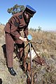 | 3,072 × 4,608 (2.06 MB) | TwinMosia | User created page with UploadWizard |
File usage
The following pages on the English Wikipedia use this file (pages on other projects are not listed):
Global file usage
The following other wikis use this file:
- Usage on ca.wikipedia.org
- Usage on es.wikipedia.org