
File:A Long Barrow - geograph.org.uk - 21533.jpg
No higher resolution available.
A_Long_Barrow_-_geograph.org.uk_-_21533.jpg (640 × 480 pixels, file size: 95 KB, MIME type: image/jpeg)
| This is a file from the Wikimedia Commons. Information from its description page there is shown below. Commons is a freely licensed media file repository. You can help. |
Summary
| Description |
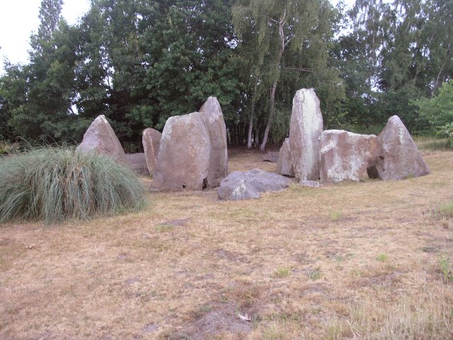
English: A Long Barrow. This has got to be the most impressive garden feature I've seen. In the grounds of a private residence, this is the best preserved long barrow in this area of Kent. What remains is the stone structure, which originally would have been covered by earth. 1,500 years older than Stonehenge, this is an ancient burial chamber built using local stones and originally covered by earth, with the chamber itself being between the two middle stones and the other stones supporting the earth structure. The central stones are about 3m tall and would have originally been topped by a capping stone (now just visible in the picture on the ground behind the stones). There are many other barrows in this area of Kent, but this has been re-built in the 1950s when the barrow was archaeologically investigated. |
| Date | |
| Source | From geograph.org.uk |
| Author | Hywel Williams |
| Attribution (required by the license) | Hywel Williams / A Long Barrow / |
| Camera location | | View this and other nearby images on: OpenStreetMap |
|---|
| Object location | | View this and other nearby images on: OpenStreetMap |
|---|
Licensing

|
This image was taken from the Geograph project collection. See this photograph's page on the Geograph website for the photographer's contact details. The copyright on this image is owned by Hywel Williams and is licensed for reuse under the Creative Commons Attribution-ShareAlike 2.0 license.
|
This file is licensed under the Creative Commons Attribution-Share Alike 2.0 Generic license.
Attribution: Hywel Williams
- You are free:
- to share – to copy, distribute and transmit the work
- to remix – to adapt the work
- Under the following conditions:
- attribution – You must give appropriate credit, provide a link to the license, and indicate if changes were made. You may do so in any reasonable manner, but not in any way that suggests the licensor endorses you or your use.
- share alike – If you remix, transform, or build upon the material, you must distribute your contributions under the same or compatible license as the original.
File history
Click on a date/time to view the file as it appeared at that time.
| Date/Time | Thumbnail | Dimensions | User | Comment | |
|---|---|---|---|---|---|
| current | 01:21, 30 January 2010 |  | 640 × 480 (95 KB) | GeographBot | == {{int:filedesc}} == {{Information |description={{en|1=A Long Barrow. This has got to be the most impressive garden feature I've seen. In the grounds of a private residence, this is the best preserved long barrow in this area of Kent. What remains is |
File usage
The following pages on the English Wikipedia use this file (pages on other projects are not listed):
Global file usage
The following other wikis use this file:
- Usage on ar.wikipedia.org
- Usage on de.wikipedia.org
- Usage on fa.wikipedia.org
- Usage on id.wikipedia.org
- Usage on ml.wikipedia.org