
File:ARPANET 1970 Map.png

No higher resolution available.
ARPANET_1970_Map.png (684 × 463 pixels, file size: 107 KB, MIME type: image/png)
| This is a file from the Wikimedia Commons. Information from its description page there is shown below. Commons is a freely licensed media file repository. You can help. |
Summary
| Description |
English: The map of ARPANET in December 1970, it contains 18 Nodes and 24 Lines.
العربية: خريطة شبكة الأربانت في ديسمبر 1970، احتوت الشبكة 18 عقدة و24 وصلة. |
| Date | |
| Source | http://digital2.library.ucla.edu/internethistory/ |
| Author | UCLA and BBN |
Licensing
This file is licensed under the Creative Commons Attribution-Share Alike 4.0 International license.
- You are free:
- to share – to copy, distribute and transmit the work
- to remix – to adapt the work
- Under the following conditions:
- attribution – You must give appropriate credit, provide a link to the license, and indicate if changes were made. You may do so in any reasonable manner, but not in any way that suggests the licensor endorses you or your use.
- share alike – If you remix, transform, or build upon the material, you must distribute your contributions under the same or compatible license as the original.
File history
Click on a date/time to view the file as it appeared at that time.
| Date/Time | Thumbnail | Dimensions | User | Comment | |
|---|---|---|---|---|---|
| current | 19:08, 10 October 2019 |  | 684 × 463 (107 KB) | Reseletti | whitepoint correction, straightened, contrast maximized, cropped to content |
| 14:06, 23 August 2017 | 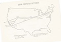 | 799 × 561 (274 KB) | Michel Bakni | User created page with UploadWizard |
File usage
The following pages on the English Wikipedia use this file (pages on other projects are not listed):
Global file usage
The following other wikis use this file:
- Usage on ar.wikipedia.org
- Usage on en.wikibooks.org
- Usage on es.wikipedia.org