
File:A4 Cockspur Street - geograph.org.uk - 1011762.jpg

No higher resolution available.
A4_Cockspur_Street_-_geograph.org.uk_-_1011762.jpg (640 × 480 pixels, file size: 89 KB, MIME type: image/jpeg)
| This is a file from the Wikimedia Commons. Information from its description page there is shown below. Commons is a freely licensed media file repository. You can help. |
Summary
| Description |
English: The A4 road, Cockspur Street, in central London. In the distance is the glass skyscraper of New Zealand House. On display is a mix of buses. The red buses are public transport buses, contracted by London Buses. There's some new double-deckers, two articulated buses, and a heritage Routemaster operating London Buses heritage route 9. Below right is a tour bus, an ex-Hong King tri-axle of The Big Bus Company. |
| Date | |
| Source | From geograph.org.uk |
| Author | Oxyman |
| Other versions | |
| Attribution (required by the license) | Oxyman / A4 Cockspur Street / |

| Camera location | | View this and other nearby images on: OpenStreetMap |
|---|
| Object location | | View this and other nearby images on: OpenStreetMap |
|---|
Licensing

|
This image was taken from the Geograph project collection. See this photograph's page on the Geograph website for the photographer's contact details. The copyright on this image is owned by Oxyman and is licensed for reuse under the Creative Commons Attribution-ShareAlike 2.0 license.
|
This file is licensed under the Creative Commons Attribution-Share Alike 2.0 Generic license.
Attribution: Oxyman
- You are free:
- to share – to copy, distribute and transmit the work
- to remix – to adapt the work
- Under the following conditions:
- attribution – You must give appropriate credit, provide a link to the license, and indicate if changes were made. You may do so in any reasonable manner, but not in any way that suggests the licensor endorses you or your use.
- share alike – If you remix, transform, or build upon the material, you must distribute your contributions under the same or compatible license as the original.
File history
Click on a date/time to view the file as it appeared at that time.
| Date/Time | Thumbnail | Dimensions | User | Comment | |
|---|---|---|---|---|---|
| current | 09:56, 23 February 2011 | 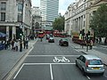 | 640 × 480 (89 KB) | GeographBot | == {{int:filedesc}} == {{Information |description={{en|1=A4 Cockspur Street}} |date=2008-10-18 |source=From [http://www.geograph.org.uk/photo/1011762 geograph.org.uk] |author=[http://www.geograph.org.uk/profile/13090 Oxyman] |permission= |other_versions= |
File usage
The following pages on the English Wikipedia use this file (pages on other projects are not listed):
Global file usage
The following other wikis use this file:
- Usage on www.wikidata.org