
File:4330Taguig City Landmarks Heritage 12.jpg

Size of this preview: 800 × 600 pixels. Other resolutions: 320 × 240 pixels | 640 × 480 pixels | 1,024 × 768 pixels | 1,280 × 960 pixels | 2,560 × 1,920 pixels | 4,608 × 3,456 pixels.
Original file (4,608 × 3,456 pixels, file size: 6.3 MB, MIME type: image/jpeg)
| This is a file from the Wikimedia Commons. Information from its description page there is shown below. Commons is a freely licensed media file repository. You can help. |
Summary
| Description |
English: Taguig Elementary School, Taguig Integrated School & Santa Ana Multi-purpose covered court, Taguig City Cronica Mart (Santa Ana, Taguig City) Grace Baptist Church (Santa Ana, Taguig City) Santa Ana-Bambang Bridge, Taguig City Taguig River Bambang, Taguig San Juan de Sahagun Chapel (Bambang, Taguig City) Taguig Church Exterior and Interior of the Archdiocesan Shrine and Parish of Saint Anne Colegio de Santa Ana Santa Ana, Taguig Bambang, Taguig City Tuktukan, Taguig City Barangays Santa Ana 14°31'12"N 121°4'54"E Tuktukan 14°31'46"N 121°4'14"E Bambang 14°31'26"N 121°4'4"E Calzada 14°32'1"N 121°4'47"E Taguig City (Note: Judge Florentino Floro, the owner, to repeat, Donor Florentino Floro of all these photos hereby donate gratuitously, freely and unconditionally all these photos to and for Wikimedia Commons, exclusively, for public use of the public domain, and again without any condition whatsoever). |
| Date | |
| Source | Own work |
| Author | Judgefloro |
| Camera location | | View this and other nearby images on: OpenStreetMap |
|---|
Santa Ana 14°31'12"N 121°4'54"E
Licensing
I, the copyright holder of this work, hereby publish it under the following license:
| This file is made available under the Creative Commons CC0 1.0 Universal Public Domain Dedication. | |
| The person who associated a work with this deed has dedicated the work to the public domain by waiving all of their rights to the work worldwide under copyright law, including all related and neighboring rights, to the extent allowed by law. You can copy, modify, distribute and perform the work, even for commercial purposes, all without asking permission.
|
File history
Click on a date/time to view the file as it appeared at that time.
| Date/Time | Thumbnail | Dimensions | User | Comment | |
|---|---|---|---|---|---|
| current | 07:33, 4 August 2018 | 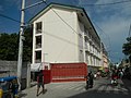 | 4,608 × 3,456 (6.3 MB) | Judgefloro | User created page with UploadWizard |
File usage
No pages on the English Wikipedia use this file (pages on other projects are not listed).