
File:2021 United Kingdom local elections for police and crime commissioners and police, fire and crime commissioners.svg

Size of this PNG preview of this SVG file: 550 × 599 pixels. Other resolutions: 220 × 240 pixels | 441 × 480 pixels | 705 × 768 pixels | 940 × 1,024 pixels | 1,880 × 2,048 pixels | 1,536 × 1,673 pixels.
Original file (SVG file, nominally 1,536 × 1,673 pixels, file size: 12.28 MB)
| This is a file from the Wikimedia Commons. Information from its description page there is shown below. Commons is a freely licensed media file repository. You can help. |
Summary
| Description |
English: Map of police districts with elections for police and crime commissioners or police, fire and crime commissioners in 2021.
Key: Police, fire and crime commissioner election
Police and crime commissioner election
No election |
| Date | |
| Source |
|
| Author | Ralbegen, using the above. |
Licensing
This file is licensed under the Creative Commons Attribution-Share Alike 3.0 Unported license.
- You are free:
- to share – to copy, distribute and transmit the work
- to remix – to adapt the work
- Under the following conditions:
- attribution – You must give appropriate credit, provide a link to the license, and indicate if changes were made. You may do so in any reasonable manner, but not in any way that suggests the licensor endorses you or your use.
- share alike – If you remix, transform, or build upon the material, you must distribute your contributions under the same or compatible license as the original.
File history
Click on a date/time to view the file as it appeared at that time.
| Date/Time | Thumbnail | Dimensions | User | Comment | |
|---|---|---|---|---|---|
| current | 17:48, 24 February 2021 | 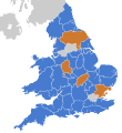 | 1,536 × 1,673 (12.28 MB) | Mirrorme22 | There is no election in West Yorkshire as the PCC is to be abolished once the combined authority mayor is elected (see: https://www.westyorkshire-pcc.gov.uk/devolution#OPCC and https://www.legislation.gov.uk/uksi/2021/112/part/10/made) |
| 20:33, 20 November 2020 |  | 1,536 × 1,673 (12.26 MB) | Ralbegen | Uploaded a work by Ralbegen, using the above. from Ordnance Survey [https://www.ordnancesurvey.co.uk/opendatadownload/products.html OpenData]: *County boundaries (from Boundary-Line product) *Coastline data for Great Britain (from VectorMap District product) with UploadWizard |
File usage
The following pages on the English Wikipedia use this file (pages on other projects are not listed):