
File:2020 China floods.svg

Size of this PNG preview of this SVG file: 753 × 599 pixels. Other resolutions: 302 × 240 pixels | 603 × 480 pixels | 965 × 768 pixels | 1,280 × 1,019 pixels | 2,560 × 2,038 pixels | 1,181 × 940 pixels.
Original file (SVG file, nominally 1,181 × 940 pixels, file size: 3.88 MB)
| This is a file from the Wikimedia Commons. Information from its description page there is shown below. Commons is a freely licensed media file repository. You can help. |
Summary
| Description |
English: An SVG locator map (developed from the maps in Category:SVG_locator_maps_of_provinces_in_China_(dark_red_location_map_scheme)) that shows in dark red the provinces of China that were most severely affected by the 2020 China floods. |
| Date | |
| Source | Own work |
| Author | Gbear605 |
Licensing
I, the copyright holder of this work, hereby publish it under the following license:
This file is licensed under the Creative Commons Attribution-Share Alike 4.0 International license.
- You are free:
- to share – to copy, distribute and transmit the work
- to remix – to adapt the work
- Under the following conditions:
- attribution – You must give appropriate credit, provide a link to the license, and indicate if changes were made. You may do so in any reasonable manner, but not in any way that suggests the licensor endorses you or your use.
- share alike – If you remix, transform, or build upon the material, you must distribute your contributions under the same or compatible license as the original.
File history
Click on a date/time to view the file as it appeared at that time.
| Date/Time | Thumbnail | Dimensions | User | Comment | |
|---|---|---|---|---|---|
| current | 03:28, 17 August 2020 | 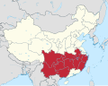 | 1,181 × 940 (3.88 MB) | Gbear605 | Uploaded own work with UploadWizard |
File usage
The following pages on the English Wikipedia use this file (pages on other projects are not listed):
Global file usage
The following other wikis use this file:
- Usage on de.wikipedia.org
- Usage on nds.wikipedia.org
- Usage on nl.wikipedia.org
- Usage on vi.wikipedia.org
- Usage on www.wikidata.org
- Usage on zh.wikipedia.org
- Usage on zh.wikinews.org
- 貴州桐梓多個鄉鎮因強降雨受災 獲救人數統計中
- 長江流域多日暴雨,災情慘重
- 湖北五大湖泊水位超汛限
- 中国南方水灾泛滥 暴雨预警范围扩大 三峡大坝安全成焦点
- 安徽黄山暴雨倾盆,屯溪镇海桥被冲毁,歙县高考语数两科推迟
- Template:2020年中国南方水灾
- 中国南方暴雨持续,多处古桥梁遭冲毁
- 华南洪涝已致3789万人受灾
- 中央气象台继续发布暴雨蓝色预警 9省市部分地区有大到暴雨
- 江苏升级洪水红色预警
- 中國內地廣泛地區現新一輪強降雨
- 習近平到安徽合肥巢湖視察水勢
- 李克強到重慶看望慰問受災群眾
- 四川乐山现“异味烟雾” 当地未发现危化企业爆炸事故
- 習近平:切實完成防汛救災後續任務
- 四川汉源昨突发山体滑坡
- 三峽水利迎戰建庫以來最大洪峰
- 洪水來襲 小伙打遊戲不肯撤離:我不能賣隊友
- 習近平稱密雲水庫鄉親為首都生態環境改善作貢獻
- 中国应急管理部:2020年南方洪涝主要灾情指标“三升两降”