
File:1964 Electoral Map.png
Size of this preview: 800 × 430 pixels. Other resolutions: 320 × 172 pixels | 640 × 344 pixels | 1,182 × 635 pixels.
Original file (1,182 × 635 pixels, file size: 171 KB, MIME type: image/png)
| This is a file from the Wikimedia Commons. Information from its description page there is shown below. Commons is a freely licensed media file repository. You can help. |
| U.S. presidential election maps from the National Atlas of the United States |
| See also: SVG maps |
| 1789 · 1792 · 1796 · 1800 · 1804 · 1808 · 1812 · 1816 · 1820 · 1824 · 1828 · 1832 · 1836 · 1840 · 1844 · 1848 · 1852 · 1856 · 1860 · 1864 · 1868 · 1872 · 1876 · 1880 · 1884 · 1888 · 1892 · 1896 · 1900 · 1904 · 1908 · 1912 · 1916 · 1920 · 1924 · 1928 · 1932 · 1936 · 1940 · 1944 · 1948 · 1952 · 1956 · 1960 · 1964 · 1968 · 1972 · 1976 · 1980 · 1984 · 1988 · 1992 · 1996 · 2000 · 2004 |
Summary
| Description |
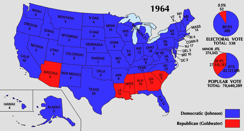
English: 1964 Electoral College Map |
| Source | https://nationalmap.gov/small_scale/printable/elections.html |
| Author | United States Geological Survey |

|
This election map image could be re-created using vector graphics as an SVG file. This has several advantages; see Commons:Media for cleanup for more information. If an SVG form of this image is available, please upload it and afterwards replace this template with
{{vector version available|new image name}}.
It is recommended to name the SVG file “1964 Electoral Map.svg”—then the template Vector version available (or Vva) does not need the new image name parameter. |
Licensing
This map was obtained from an edition of the National Atlas of the United States. Like almost all works of the U.S. federal government, works from the National Atlas are in the public domain in the United States.
Online access: NationalAtlas.gov | 1970 print edition: Library of Congress, Perry-Castañeda Library
|
File history
Click on a date/time to view the file as it appeared at that time.
| Date/Time | Thumbnail | Dimensions | User | Comment | |
|---|---|---|---|---|---|
| current | 22:05, 25 June 2008 |  | 1,182 × 635 (171 KB) | Tallicfan20 | |
| 21:40, 25 June 2008 |  | 1,182 × 635 (171 KB) | Tallicfan20 | better | |
| 08:18, 24 May 2008 |  | 1,182 × 635 (160 KB) | Tallicfan20 | ||
| 17:17, 16 May 2008 |  | 1,182 × 635 (103 KB) | Tallicfan20 | {{Information |Description=1964 electoral college map |Source=National Atlas |Date=5/16/2008 |Author=National Atlas |Permission=PD |other_versions= }} {{PD-USGov-Atlas}} |
File usage
The following pages on the English Wikipedia use this file (pages on other projects are not listed):
Global file usage
The following other wikis use this file:
- Usage on fi.wikipedia.org
- Usage on fr.wikipedia.org
- Usage on hu.wikipedia.org
- Usage on it.wikipedia.org
- Usage on no.wikipedia.org
- Usage on pt.wikipedia.org
- Usage on sv.wikipedia.org
- Usage on uk.wikipedia.org
- Usage on zh.wikipedia.org