
File:1899 Irish county council elections - Ward and Council Control.svg

Size of this PNG preview of this SVG file: 510 × 336 pixels. Other resolutions: 320 × 211 pixels | 640 × 422 pixels | 1,024 × 675 pixels | 1,280 × 843 pixels | 2,560 × 1,687 pixels.
Original file (SVG file, nominally 510 × 336 pixels, file size: 11.49 MB)
| This is a file from the Wikimedia Commons. Information from its description page there is shown below. Commons is a freely licensed media file repository. You can help. |
Summary
| Description |
English: Map of the 1899 Irish county council elections, showing control by council (left) and results by electoral division (right).
Most divisions elected 1 councillor, although a small number (eg Athlone) elected 2. Electoral Division returned 1 Nationalist Councillor
Electoral Division returned 1 Parnellite/Redmondite Councillor
Electoral Division returned 1 United Irish League Councillor
Electoral Division returned 1 Labour-Nationalist Councillor
Electoral Division returned 1 Unionist Councillor |
| Date | |
| Source | Own work |
| Author | MrPenguin21 |
Licensing
I, the copyright holder of this work, hereby publish it under the following license:
This file is licensed under the Creative Commons Attribution-Share Alike 4.0 International license.
- You are free:
- to share – to copy, distribute and transmit the work
- to remix – to adapt the work
- Under the following conditions:
- attribution – You must give appropriate credit, provide a link to the license, and indicate if changes were made. You may do so in any reasonable manner, but not in any way that suggests the licensor endorses you or your use.
- share alike – If you remix, transform, or build upon the material, you must distribute your contributions under the same or compatible license as the original.
File history
Click on a date/time to view the file as it appeared at that time.
| Date/Time | Thumbnail | Dimensions | User | Comment | |
|---|---|---|---|---|---|
| current | 21:13, 7 November 2020 |  | 510 × 336 (11.49 MB) | MrPenguin21 | Updated Patrickswell in Limerick - Lord Emly was a Labour-Nationalist, rather than a Unionist (as wrongly reported in some publications) |
| 23:42, 2 November 2020 | 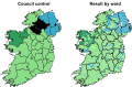 | 510 × 336 (11.49 MB) | MrPenguin21 | Fixed Meath (small number of local Unionist aristocrats returned). Note: Tipperary to be split into North & South ridings, reflecting administrative counties. | |
| 23:32, 2 November 2020 |  | 510 × 336 (11.49 MB) | MrPenguin21 | Uploaded own work with UploadWizard |
File usage
The following pages on the English Wikipedia use this file (pages on other projects are not listed):
Global file usage
The following other wikis use this file:
- Usage on ga.wikipedia.org
- Usage on www.wikidata.org