
File:1873 Beers Map of Flushing and College Point, Queens, New York - Geographicus - Kissena Creek & Central RR 2A.jpg

Size of this preview: 450 × 600 pixels. Other resolutions: 180 × 240 pixels | 360 × 480 pixels | 576 × 768 pixels | 768 × 1,024 pixels | 1,575 × 2,100 pixels.
Original file (1,575 × 2,100 pixels, file size: 1.92 MB, MIME type: image/jpeg)
| This is a file from the Wikimedia Commons. Information from its description page there is shown below. Commons is a freely licensed media file repository. You can help. |
Summary
| Flushing, Queens Co. L.I. | |||
|---|---|---|---|
| Artist | |||
| Author | |||
| Title |
Flushing, Queens Co. L.I. |
||
| Description |
English: A scarce example of Fredrick W. Beers’ map of Flushing and College Point, Queens, New York. published in 1873. Outlined in blue is the former Kissena Creek, which flowed east, north, then west towards Flushing Creek. Highlighted in black is the former Central Railroad of Long Island, which ran east from Flushing to Garden City, Long Island. |
||
| Date | 1873 | ||
| Accession number |
Geographicus link: Flushing-beers-1873 |
||
| Source/Photographer |
Atlas of Long Island, New York. From Recent Actual Surveys and Records Under the Superintendence of F. W. Beers. (1873 First Edition).
|
||
| Other versions | |||

Licensing
|
This is a faithful photographic reproduction of a two-dimensional, public domain work of art. The work of art itself is in the public domain for the following reason:
The official position taken by the Wikimedia Foundation is that "faithful reproductions of two-dimensional public domain works of art are public domain".
This photographic reproduction is therefore also considered to be in the public domain in the United States. In other jurisdictions, re-use of this content may be restricted; see Reuse of PD-Art photographs for details. |
File history
Click on a date/time to view the file as it appeared at that time.
| Date/Time | Thumbnail | Dimensions | User | Comment | |
|---|---|---|---|---|---|
| current | 05:34, 7 July 2018 | 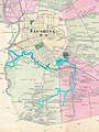 | 1,575 × 2,100 (1.92 MB) | Tdorante10 | User created page with UploadWizard |
File usage
The following pages on the English Wikipedia use this file (pages on other projects are not listed):