
File:1855 Colton Map of Antarctica, the South Pole, or the Southern Polar Regions - Geographicus - SouthernRegions-colton-1855.jpg

Size of this preview: 491 × 599 pixels. Other resolutions: 197 × 240 pixels | 393 × 480 pixels | 629 × 768 pixels | 839 × 1,024 pixels | 1,678 × 2,048 pixels | 3,277 × 4,000 pixels.
Original file (3,277 × 4,000 pixels, file size: 2.73 MB, MIME type: image/jpeg)
| This is a file from the Wikimedia Commons. Information from its description page there is shown below. Commons is a freely licensed media file repository. You can help. |
| J. H. Colton: Southern Regions.
( |
|||||||||||||||||||||
|---|---|---|---|---|---|---|---|---|---|---|---|---|---|---|---|---|---|---|---|---|---|
| Artist |
|
||||||||||||||||||||
| Title |
Southern Regions. |
||||||||||||||||||||
| Description |
English: An excellent example of Colton’s c. 1855 map of the South Pole, Antarctica, or the Southern Polar Regions. Sows the Great Southern Continent with both solid and tentatively sketched in borders. Notes the travels of important Antarctic explorers of the previous 20 years or so, including Wilkes (1840), Bellinghausen (1820), Ross (1840 - 1843), KIempt (1833), Cook (1773 - 1774 ) and Biscoe (1831). Generally gives an excellent overview of the state Antarctic exploration and discovery around 1855. Prepared by J. H. Colton as map no XIII in the 1855 or 1856 edition of Colton's Atlas of The World . Published from Colton’s 172 William Str. Office in New York. |
||||||||||||||||||||
| Date | 1855 (dated) | ||||||||||||||||||||
| Dimensions | height: 16 in (40.6 cm); width: 13 in (33 cm) | ||||||||||||||||||||
| Accession number |
Geographicus link: SouthernRegions-colton-1855 |
||||||||||||||||||||
| Source/Photographer |
Colton's Atlas Of The World, Illustrating Physical And Political Geography. By George W. Colton. (1855 or 1856 edition).
|
||||||||||||||||||||
| Permission (Reusing this file) |
|
||||||||||||||||||||

File history
Click on a date/time to view the file as it appeared at that time.
| Date/Time | Thumbnail | Dimensions | User | Comment | |
|---|---|---|---|---|---|
| current | 18:40, 17 March 2011 | 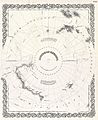 | 3,277 × 4,000 (2.73 MB) | BotMultichill | {{subst:User:Multichill/Geographicus |link=http://www.geographicus.com/P/AntiqueMap/SouthernRegions-colton-1855 |product_name=1855 Colton Map of Antarctica, the South Pole, or the Southern Polar Regions |map_title=Southern Regions. |description=An excelle |
File usage
The following pages on the English Wikipedia use this file (pages on other projects are not listed):
Global file usage
The following other wikis use this file:
- Usage on ja.wikipedia.org