
File:1849 Railroad Map of New England & Eastern New York.jpg

Size of this preview: 478 × 599 pixels. Other resolutions: 191 × 240 pixels | 383 × 480 pixels | 612 × 768 pixels | 816 × 1,024 pixels | 1,633 × 2,048 pixels | 7,882 × 9,884 pixels.
Original file (7,882 × 9,884 pixels, file size: 19.41 MB, MIME type: image/jpeg)
| This is a file from the Wikimedia Commons. Information from its description page there is shown below. Commons is a freely licensed media file repository. You can help. |
| Warning | The original file is very high-resolution. It might not load properly or could cause your browser to freeze when opened at full size. |
|---|
| Description |
English: Railroad Map of New England & Eastern New York, published 1849 |
||
| Date | |||
| Source | David Rumsey Map Collection | ||
| Author | J.H. Goldthwait | ||
| Permission (Reusing this file) |
|
File history
Click on a date/time to view the file as it appeared at that time.
| Date/Time | Thumbnail | Dimensions | User | Comment | |
|---|---|---|---|---|---|
| current | 03:34, 27 August 2013 | 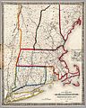 | 7,882 × 9,884 (19.41 MB) | Pi.1415926535 | {{Information |Description ={{en|1=''Railroad Map of New England & Eastern New York'', published 1849}} |Source =[http://www.davidrumsey.com/luna/servlet/s/l4019i David Rumsey Map Collection] |Author =J.H. Goldthwait |Date ... |
File usage
The following pages on the English Wikipedia use this file (pages on other projects are not listed):
Global file usage
The following other wikis use this file:
- Usage on zh.wikipedia.org
- Portal:美國/特色條目
- 1850年大西洋飓风季
- Wikipedia:优良条目/2015年1月
- Wikipedia:优良条目/2015年1月3日
- Wikipedia:优良条目/1850年大西洋飓风季
- Wikipedia:典范条目/2014年11月
- Wikipedia:典范条目/2014年11月1日
- Wikipedia:典范条目/1850年大西洋飓风季
- Portal:美国/特色条目/214
- Wikipedia:典范条目/2017年1月
- Wikipedia:典范条目/2017年1月6日
- Wikipedia:典范条目/2017年1月7日
- Module:Carousel/doc
- Wikipedia:典范条目/2019年5月
- Wikipedia:典范条目/2019年5月27日
- Wikipedia:典范条目/2023年5月
- Wikipedia:典范条目/2023年5月6日